
Sign up to receive email notices of recent acquisitions.
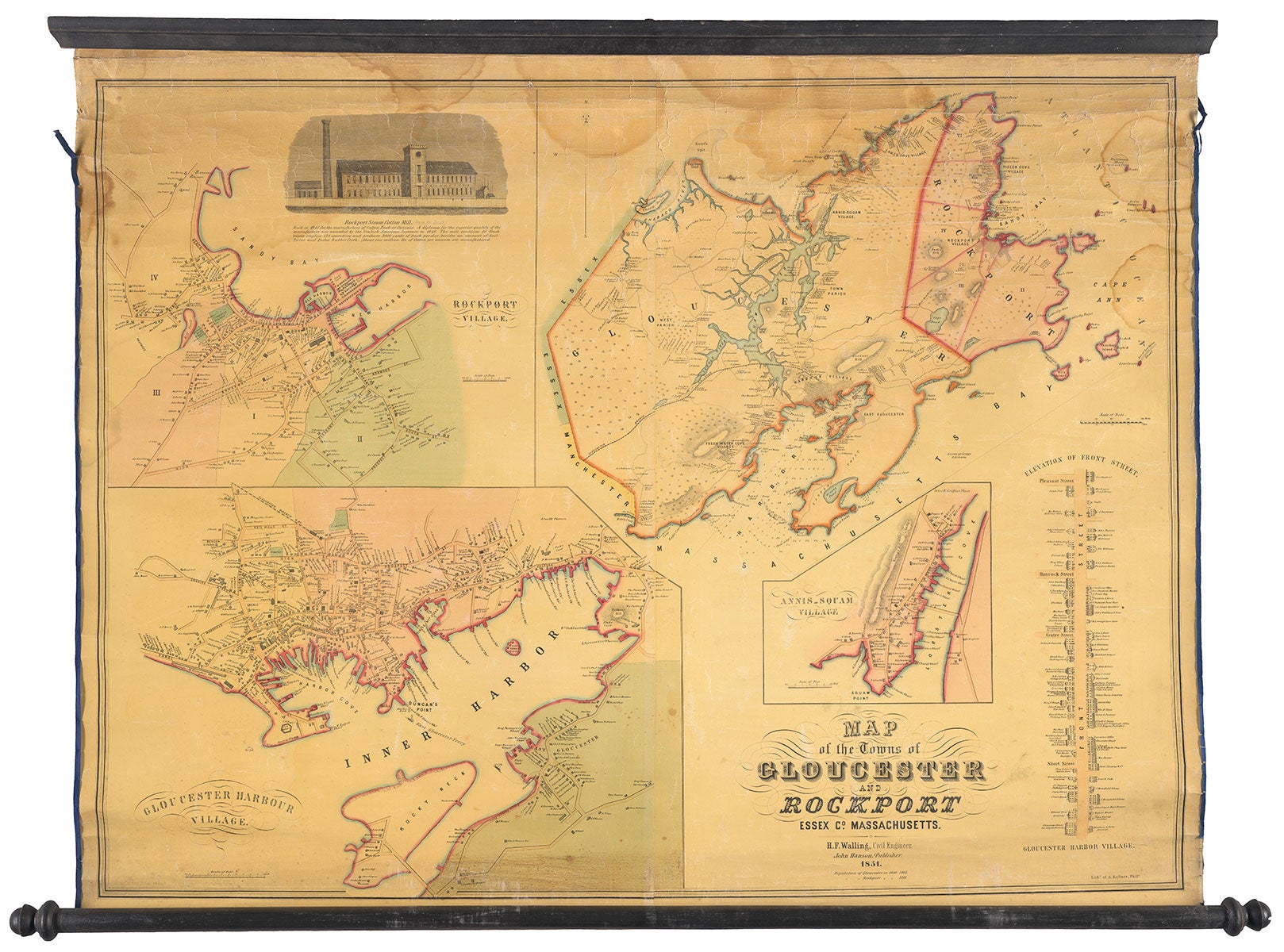
Map of the Towns of Gloucester and Rockport.
Philadelphia: John Hanson; Philadelphia: A. Kollner, 1851. Hand-colored lithograph mounted on original linen and affixed to wooden rods, 44” x 33.5” plus margins; 37.5” x 50.75” overall (including rods). An attractive map of Gloucester and Rockport by one of the most accomplished and prolific U.S. mapmakers of the mid-nineteenth century. The map is divided into four sections, with maps of Rockport Village and Gloucester Harbor Village on the left, a general map of Rockport and Gloucester at the upper right, and an inset map of Anni-Squam Village in the lower right. Indicated on this composite map are many landowners, manufacturers, streets, wharfs, harbors, villages, ferries, routes, creeks, churches, hospitals, canals, hills, islands, rivers, pastures, coves, and much more. A strip “elevation” of Front Street appears along the lower right edge identifying houses and businesses along the street. Appearing in the upper left is an inset illustration of Rockport Steam Cotton Mill, which was built in 1847 and is noted here as manufacturing one million pounds of cotton per year. Below the title the populations of Gloucester and Rockport in 1850 are given: 7805 and 3213 respectively. Relief is shown by hachure and depths are indicated by soundings. Born in Burrillville, Rhode Island, Henry F. Walling (1825-1889) was a civil engineer, surveyor, and mapmaker who began conducting surveys of Massachusetts in the early 1850s. After a spike in business, he moved his headquarters to Boston. Wallling prepared numerous town plans on contract for municipal officials, and after providing them a certain number of maps he was free to sell additional copies on his own. In 1853, he published seven maps for towns in Essex, Middlesex, Norfolk, Plymouth and Worcester counties. Walling was appointed by the Legislature in 1852 as Superintendent of the State Map of Massachusetts. Between 1850 and 1857, he and his associates prepared up to fifty Massachusetts town plans. In 1855 the Massachusetts governor called upon him to update and revise Simeon Borden’s state map of Massachusetts, originally published in 1842. By 1860 he had surveyed and published maps of all fourteen Massachusetts counties and began extending his activity to other New England states. WorldCat records four copies, at the British Library, Boston Public Library, Harvard, and State Library of Massachusetts. A scarce and handsome map of these North Shore Massachusetts towns. REFERENCES: Ristow, Walter W. American Maps and Mapmakers (Detroit: Wayne State University Press, 1985), pp. 327-331; Garver, J.G. Surveying the Shore, Historic Maps of Coastal Massachusetts, 1600–1930 (Beverly, MA: Commonwealth Editions, 2006). CONDITION: Good, some light damp stains at top, light creasing and occasional rubbing throughout, some losses to selvage at left and right edges, light discoloration along bottom; but overall quite bright, clean,and attractive.
Item #5249
Sold