
Sign up to receive email notices of recent acquisitions.
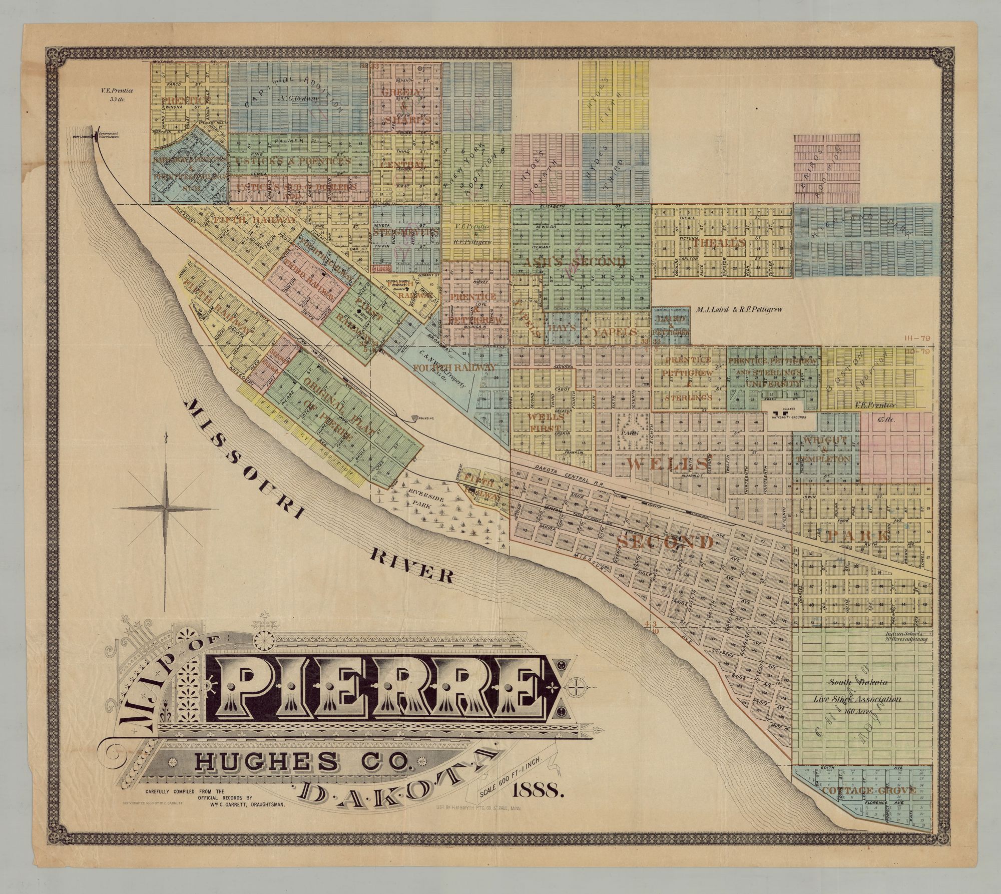
Map of Pierre Hughes Co. Dakota. Carefully compiled from the official records by Wm. C. Garrett, Draughtsman.
Saint Paul, Minn.: Lith. by H. M. Smith Ptg. Co., 1888. Chromolithographic map on banknote paper, with touches of hand coloring, 25” x 28.5” plus margins. A rare and early map of the city of Pierre, published eight years after it was founded, and one year before it became the capital of the newly formed state of South Dakota. Founded in 1880, during the Great Dakota Boom of 1878-1887, Pierre began as a ferry landing on the banks of the Missouri River, near the Dakota Central Railroad terminal. At the time this map was published a political battle was being fought by those advocating for Pierre as the state capitol and those favoring other cities, such as Mitchell (which was closer to the center of population,) Huron, and others. Being closer to the geographical center of the state and located on the Missouri River, Pierre won by a large margin in a state-wide vote.
This map identifies the original plat of Pierre on the waterfront as well as sections of railway property along the rail line, two parks (one on the waterfront), the South Dakota Livestock Association land (160 acres), a lot designated “college university grounds,” and various lots identified by owner, some of them bearing printed identifications and others manuscript. One parcel is marked “Hilger’s,” for John D. Hilger, of the firm of J.D. Hilger & Company, who was instrumental in naming the town "Pierre" (after Pierre Choteau, Jr., the namesake of Fort Pierre Choteau, across the river) following his arrival in 1880. A note in the lot belonging to the Livestock Association on the lower right is the only trace of the land’s former occupants, the Arikara people. It reads “Indian Schools 20 Acres adjoining,” with an arrow pointing east. A bold and handsome title in the Eastlake style appears in the lower left section. The draughtsman, William C. Garrett, is obscure. We can find no record of any other map from his hand. Rare. OCLC records only one copy, at Yale. Not in AMPR, Phillips, Rumsey, Streeter or Eberstadt. CONDITION: Good, fold marks and wrinkles, old colored pencil annotations bearing witness to its use by the original owner.
Item #3053
Price: $4,500.00