
Sign up to receive email notices of recent acquisitions.
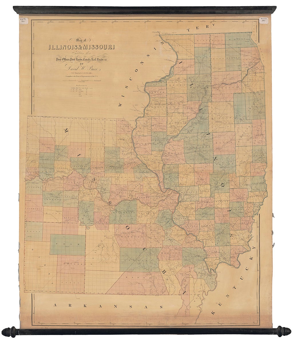
Map of Illinois & Missouri Exhibiting the Post Offices, Post Roads, Canals, Rail Roads, &c. by David H. Burr. (Late Topographer to the Post Office.) Geographer to the House of Representatives of the U.S.
[Washington, D. C.?]: David Burr; and [London:] John Arrowsmith, 1839. Hand-colored wall map printed on two joined sheets, mounted on original linen and attached to wooden rods, 48.25” x 37.5” plus margins. David Burr’s rare and very fine Map of Illinois & Missouri, from his series of large scale postal route maps published in 1839, in an excellent state of preservation. Burr was appointed topographer to the Post Office Department in 1832. As noted by Ristow, he “had access to a large volume of geographical data submitted by local postmasters throughout the country. He used this information to compile his Map of the United States of North America, with Parts of the Adjacent Countries and twelve maps of the individual states or groups of states...The post office maps were sold separately or assembled with the sheets folded in quarters and bound in a large folio volume titled The American Atlas…” The maps identify towns with post offices and the distances between them. A key identifies roads traversable by either four horse coaches, two horse stages or single horse sulkies. Schwartz and Ehrenberg note that “The final year of the decade [the 1830s] produced two important cartographic works…The final contribution was David H. Burr’s exquisite atlas of postal maps…Burr’s set of maps sold for $75.00, colored and mounted on cloth in a portfolio; separate sheets sold for $5.00 each. Despite the fact that these maps were prepared under the direction of the postmaster General, each postmaster had to buy his own maps since they were privately produced and Congress had not authorized their purchase.” Complete sets of Burr’s postal maps are exceptionally rare, and the individual maps are very scarce in the marketplace. OCLC records only two complete sets, at the Library of Congress and in the Rumsey collection. As noted by Rumsey, “John Arrowsmith engraved the plates in London, an unusual collaboration at this late a date between an American cartographer and a London engraver.” The result of this collaboration is of a very high order. A rare and handsome map. OCLC records eight copies. CONDITION: Excellent, an unusually clean, bright copy, two old paper library accession labels in the margins at the top of the map, inconspicuous library markings in lower right margin, silk selvage largely deteriorated. REFERENCES: Phillips, p. 328; Rumsey 0104.012. Ristow, p. 106.
Item #3057
Sold