
Sign up to receive email notices of recent acquisitions.
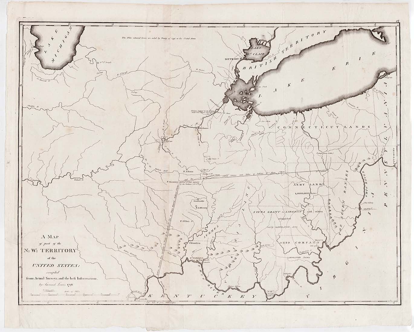
A Map of the N: W: Territory of the United States: compiled from actual surveys and the best information.
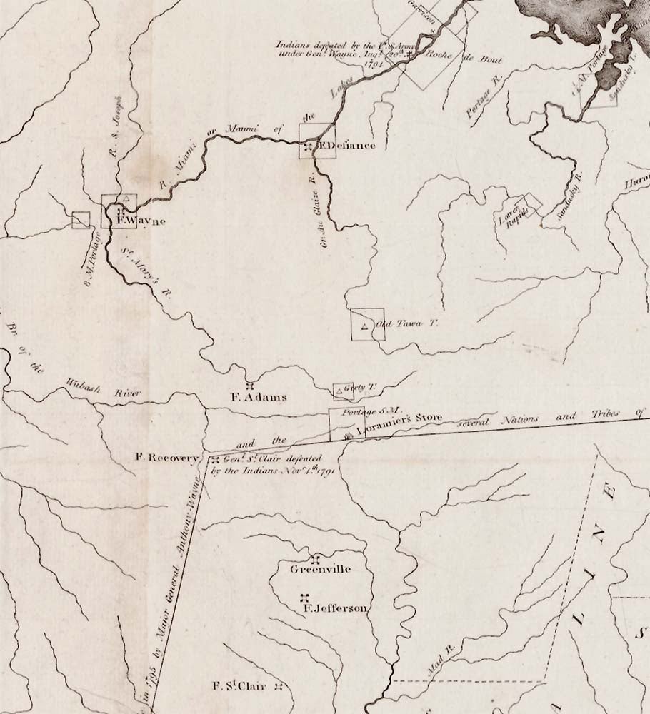
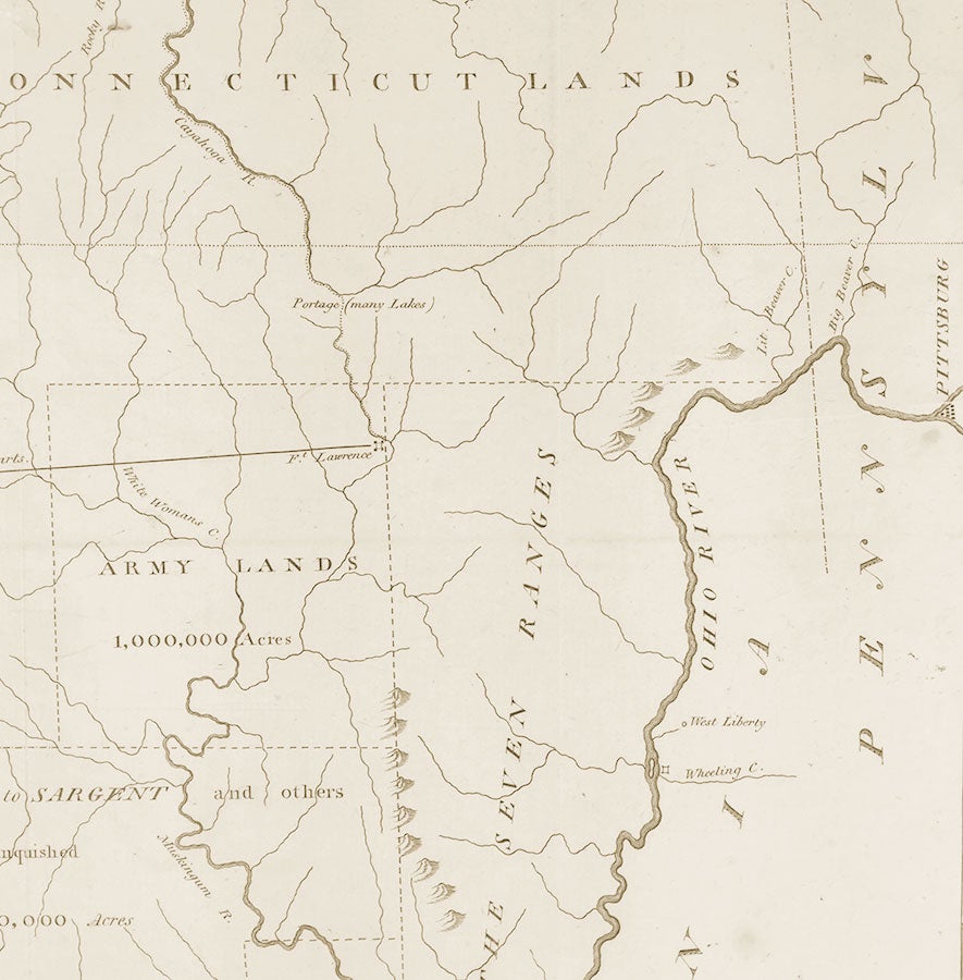
[Philadelphia: Matthew Carey, 1796]. Engraving printed on two joined sheets, 19” x 25.625” plus margins. An important map of the old Northwest Territory, compiled shortly after the conclusion of the Treaty of Greenville (1795), and among the first to reflect the events and developments at the end of the Northwest Indian War. The map extends from western Pennsylvania and Virginia to the foot of Lake Michigan and due south, embracing all of present day Ohio and Indiana, as well as portions of lower Michigan, eastern Illinois, and northern Kentucky. Following St. Clair’s defeat at the hands of the Western Confederacy in November of 1791, President George Washington ordered General Anthony Wayne to organize a fighting force to take control of the Northwest Territory. Wayne established Fort Recovery (1793–94) at the site of St. Clair’s defeat then continued northward, building Forts Adams and Defiance ahead of his main force. On 20 August, 1794, Wayne attacked Indian Confederacy forces in the Battle of Fallen Timbers, winning a decisive victory. Hostilities ended with the Treaty of Greenville, by which the native people ceded to the United States lands south and east of a boundary that began roughly at the mouth of the Cuyahoga River. Lewis’s map shows the forts constructed by Wayne, including Fort Recovery, which is accompanied by a notation regarding St. Clair’s defeat, as well as Forts Adams, Defiance and Wayne. These and other forts shown constituted a line of defense that extended from Detroit to Cincinnati. A notation along the Maumee River marks the location of the Battle of Fallen Timbers. The “Indian boundary line” established by the treaty is shown extending from Fort Lawrence on the Cuyahoga to Fort Recovery, then south to a point on the Ohio River opposite its confluence with the Kentucky River. Other lands ceded are identified by squares, including six square miles at the mouth of the Chicago River. Accordingly, the future Fort Dearborn (built 1803) is shown at Chicago. These additional plots of ceded land were meant to be colored green, but are here left uncolored. Also noted on the map are Connecticut Lands, Army Lands, Ohio Company Lands and the “Siota Grant to Sargent and others.” This map was published separately but was also included in editions of Matthew Carey’s General Atlas published in 1800, 1802, 1804, and 1811. Wheat & Brun indicates that it also appeared in atlases of 1796 and 1814, but the title pages we have examined of the 1796 General Atlas do not list it, nor does it appear on the title page of the 1814 edition, for which Carey prepared many new maps and revised others. Evans gives January 17, 1797 as the date of copyright issued to Carey, although the map carries a publication date of 1796. The copy offered here is from Carey’s General Atlas of 1802. This is the second state of the map, with the addition of the plate number “47” in the upper right corner. REFERENCES: Wheat & Brun 678, making no mention of a second state; Rumsey #4863.047. CONDITION: Very good, a few faint touches of foxing, re-margined at lower left corner.
Item #3396
Sold