
Sign up to receive email notices of recent acquisitions.
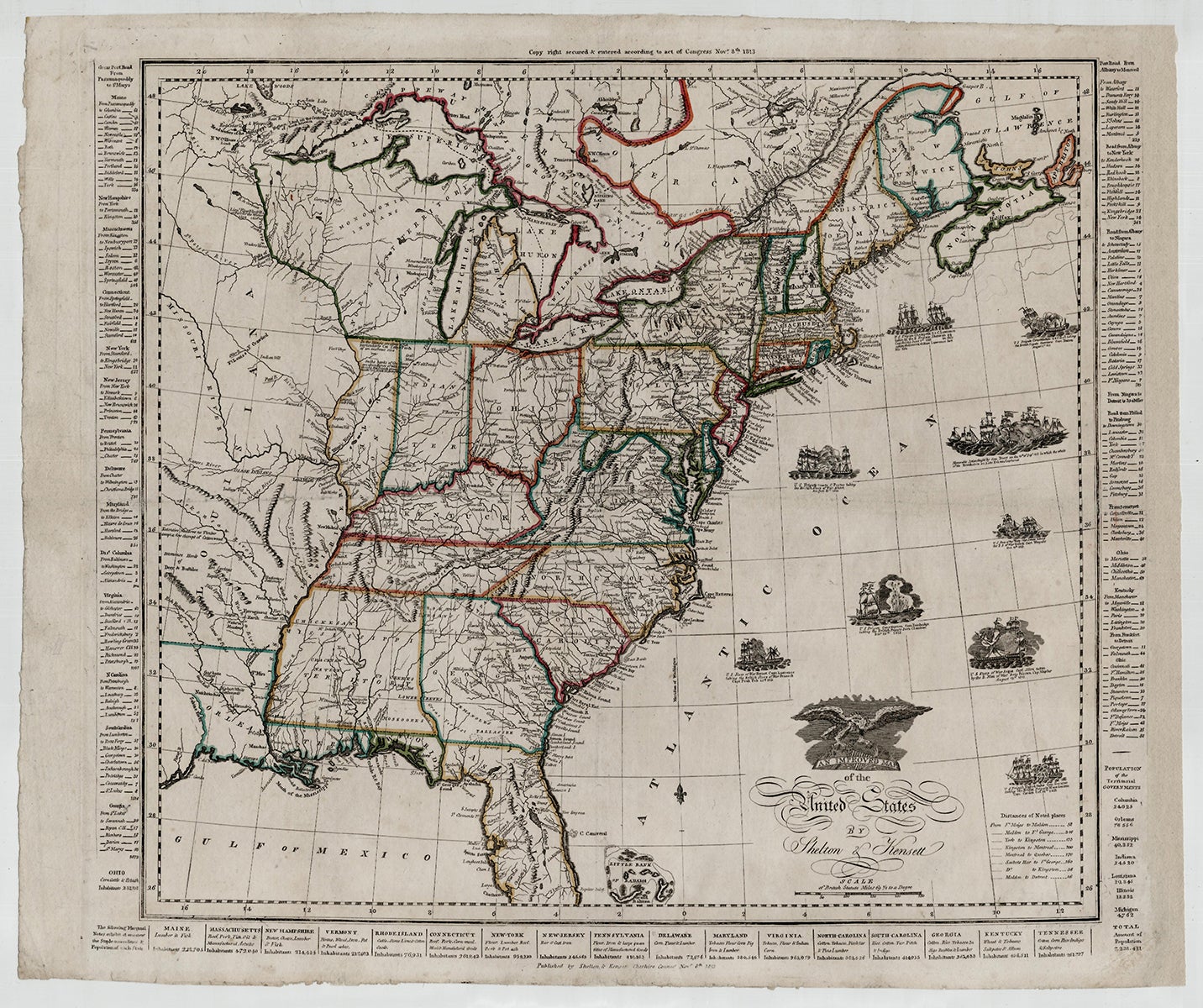
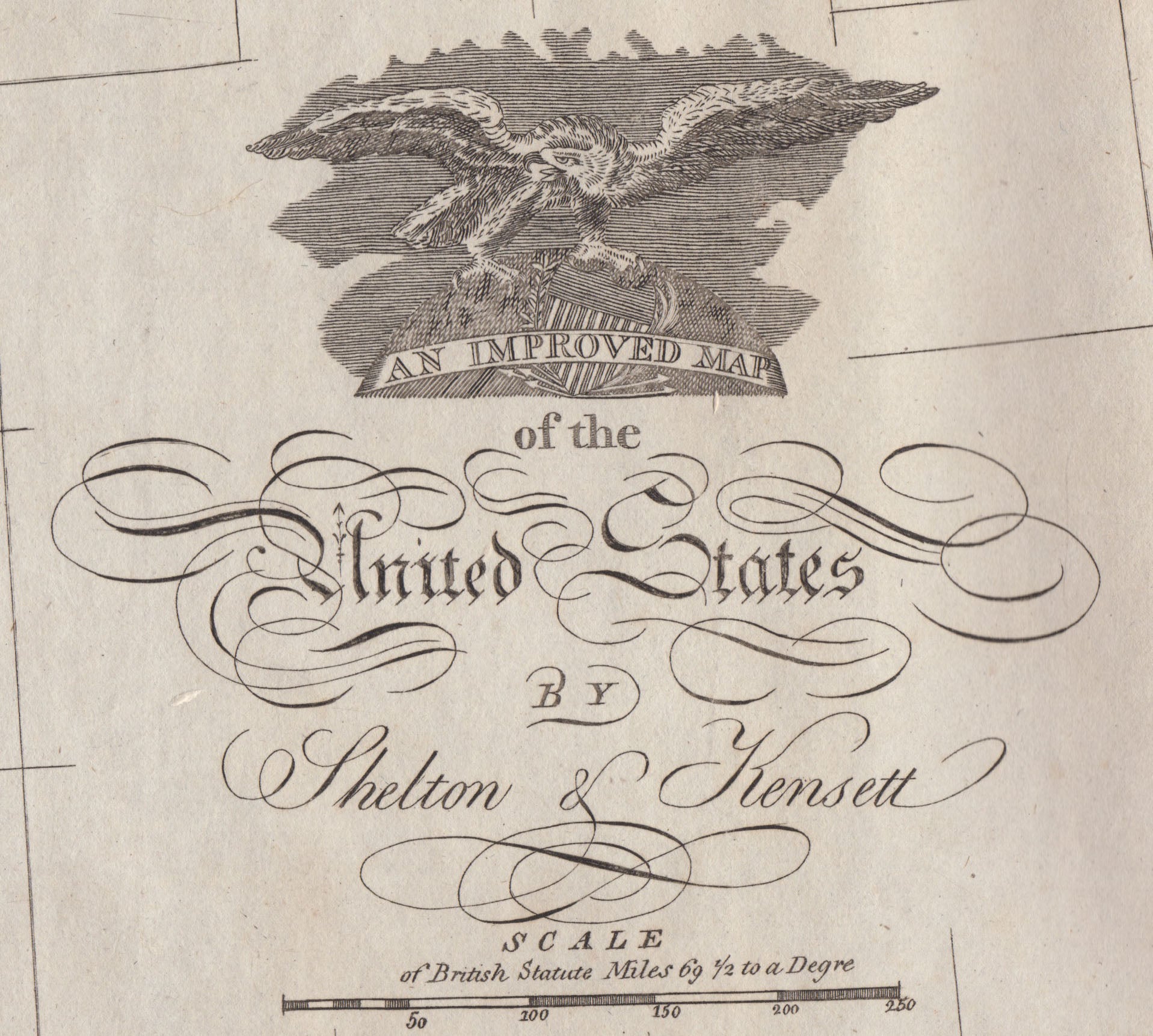
An Improved Map of the United States.
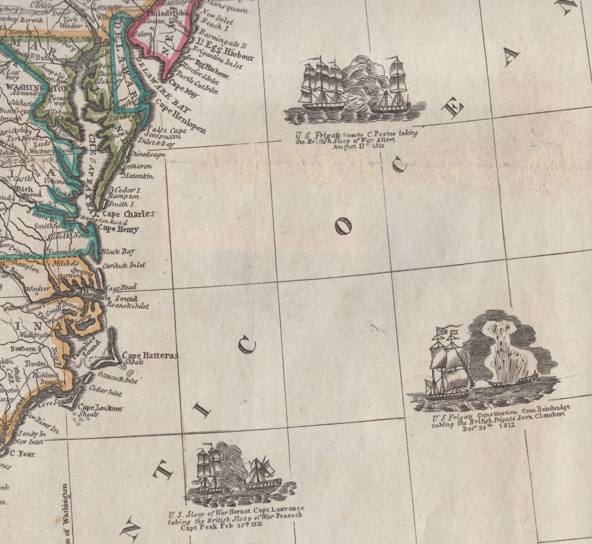
Cheshire, Connecticut: Shelton & Kensett, Nov. 8th, 1813. Engraving, 17.5” x 20.5” plus text borders and margins; outline color retouched. Shelton & Kensett’s scarce War of 1812 map, engraved by renowned Connecticut engraver Amos Doolittle, with vignettes of important naval battles. This charming and evocative map depicts the United States, a portion of Canada, and Florida (then still a Spanish possession), including the separately identified territory of West Florida—a region annexed by James Madison in 1810 and claimed as part of the Louisiana Purchase. Immediately adjacent is Orleans Territory, largely corresponding to present day Louisiana. Also depicted to the north is a portion of Louisiana Territory just west of the Mississippi. Although published after Louisiana was admitted to the Union in 1812, the map does not reflect this development, likely due to its being engraved prior to statehood. Interesting notes evoking the frontier appear in the western portion of the map. In Louisiana, the “Highest White Settlement” on the Red River is identified, and on the Arkensaw River “Hackerton’s Settlement” and a region populated by “French Hunters” are noted. Appearing between the Mississippi and the Illinois Rivers are notes reading “In the IIlinois are plenty of fish, particularly Cat, Carp & Perch of enormous size” and “On the banks of the Illinois are abundance of wild grapes. In 1769 the French planters made 110 hhds of strong wine.” Another note along the upper Mississippi reads “Lieut Pike’s Block H or Post for the winter of 1805 1806.” Appearing to the left and right of the map are lists of states with post road distances between cities. Listed across the bottom are the various states and the “staple commodities and population of each state.” Perhaps the most notable features of this map are the vignettes depicting War of 1812 naval battles, and celebrating American prowess and heroism—the only appearance of such imagery found on an American map published during the War. Represented are such notable American victories as the “Memorable action fought by Com. Perry on the 10th of Sept 1813 in which the whole of the British force on Lake Erie was captured” and such defeats as that of the U. S. Chesapeake taken by the British Frigate Shannon, in which action “the brave & gallant Lawrence lost his life.” Some four variants of this map are known. The first state, dated July 6, 1813, includes seven vignettes, and a second state bearing the same date, but likely revised in October of the same year, carries ten vignettes. Both states bear the same engraving credit: “Engraved by A. Doolittle New Haven & T. Kensett Cheshire.” The map offered here is the third version and, for reasons that are not clear, was printed from an entirely different plate, as close comparison of these maps reveals. It is dated Nov. 8th 1813, features nine vignettes, and carries an engraving credit reading “Engraved by A. Doolittle New Haven, AE 60.” (according to Donald O’Brien, Doolittle mistook his age, as he did not turn sixty until the following May). Also known is a variant published by Lewis Robinson in 1825. Amos Doolittle (1754–1832) was born in Cheshire, Connecticut, where he learned the rudiments of engraving on metal while apprenticed to local silversmith Eliakim Hitchcock. After completing his apprenticeship, he moved to New Haven, likely in 1774 or early 1775. Soon after arriving, he joined the local militia and marched to Cambridge under the command of Benedict Arnold just a few days after the Battle of Lexington & Concord. Animated by patriotic fervor and sensing an opportunity, Doolittle visited the battlefield, likely in the company of artist Ralph Earl (1751-1801), who is thought to have made a series of sketches of the battle and its setting. Upon returning to New Haven, Doolittle made a set of four engravings based on Earl’s drawings, which he advertised in the Connecticut Journal for December 13, 1775. These were Doolittle’s first engravings and would become the most iconic images of the Revolutionary War. Eventually establishing a shop where he sold his silverwork and miscellaneous items while developing his engraving business, Doolittle went on to engrave all manner of ephemera, a multitude of illustrations and maps for books, and numerous individually published prints and maps. The first map for separate publication that he engraved was William Blodget’s A Topographical Map of the State of Vermont (1789). Other notable maps to his credit include Connecticut From the Best Authorities (c. 1794), James Whitelaw’s A Correct Map of the State of Vermont (1796), Plan of New Haven (1812), and A Map of the United States and British Provinces of Upper and Lower Canada (1816). The latter map, like the first two issues of the map offered here, was engraved in concert with Thomas Kensett, a Cheshire, Connecticut engraver and publisher, who, along with his partner Dr. Charles Shelton, published numerous Doolittle-engraved maps and satirical prints. A highly appealing War of 1812 map, by an engraver much-distinguished for his contribution to American historical iconography and cartography. REFERENCES: Olds, Bits and Pieces of American History #395 (1st state); Rumsey #2956 (1st state); Stauffer, American Engravers Upon Copper and Steel, Vol. 3, 355 (1st state); Phillips, Maps of America, p. 878; O’Brien, Donald C. Amos Doolittle : Engraver of the New Republic, pp. 37; Tooley’s Dictionary of Mapmakers, A–D vol., p. 380 & K–P vol., p. 17. CONDITION: Very good, old vertical and horizontal fold marks flattened and scarcely noticeable, a few quite small holes associated with folds expertly filled in, engraving credit faintly printed.
Item #3592
Sold