
Sign up to receive email notices of recent acquisitions.
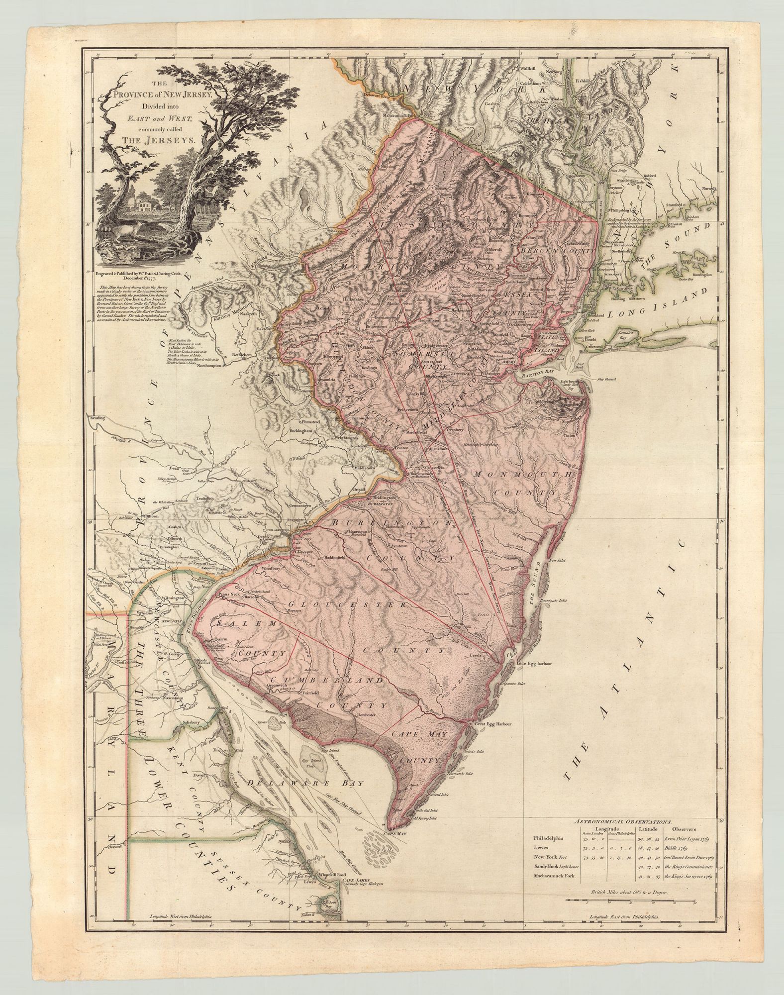
The Province of New Jersey, Divided Into East and West, Commonly Called the Jerseys.
London: Engraved & Published by Wm. Faden, Charing Cross, December 1st 1777. Hand-colored engraving, 30.75” x 22.25” plus margins; number “13” inscribed in an early hand in upper right corner of verso. The first of three editions of this seminal Revolutionary War-era map of New Jersey, the first to depict New Jersey's resolved northern border with New York, and the standard geographic representation of the state until well into the 19th century. This handsome map depicts the whole of New Jersey, as well as portions of New York, Pennsylvania, Delaware and Maryland. Published for the use of the British military, it provides a wealth of detail regarding topography, roads, waterways, forests, mills, ferries, dwellings, etc. Also identified is a fortified Valley Forge in Pennsylvania. Two lines bisect the state which represent the boundary lines between the old colonies of East and West Jersey: "Keith's Line," referring to the 1687 demarcation of the boundary by surveyor George Keith, and the re-drawn “Lawrence Line” of 1743. Gracing the upper-left corner, a cartouche depicts a farmhouse nestled between two trees; in the foreground a raccoon is shown chasing a squirrel. In the bottom right, Astronomical Observations are provided. Faden's representation of New Jersey was based on the 1769 manuscript maps of British military surveyor Bernard Ratzer, which were undertaken at the behest of George III to resolve a century-long boundary dispute between New York and New Jersey. Ratzer’s line is identified on the chart as the “Boundary as Settled by the Commissioners in 1769.” Two years prior to producing this map, Faden was named official geographer to the King. Faden combined Ratzer's work with surveys of the northern part of New Jersey made by Gerard Banker, which came to Faden by way of John Murray, the Earl of Dunmore and former governor of Virginia. Faden's New Jersey would be included in his North American Atlas, an important cartographic record of the early years of the American Revolution, based on information obtained by first-hand observation. Not only the most significant map of this area from the period, it was also, the largest, most detailed, and most precise map made of New Jersey—making it the most remarkable representation of the state produced at that time. Faden's map was frequently consulted during the Revolution. An important and attractive map of Revolutionary-era New Jersey CONDITION: Very good, old creases flattened. REFERENCES: Cumming, British Maps of Colonial America, p. 22; Phillips, List of Maps of America, p. 487; Schwartz & Enhrenberg, Mapping of America, p. 193. Snyder, Mapping of New Jersey, pp. 57-59.
Item #4259
Sold