
Sign up to receive email notices of recent acquisitions.
Welcome to Berkeley.
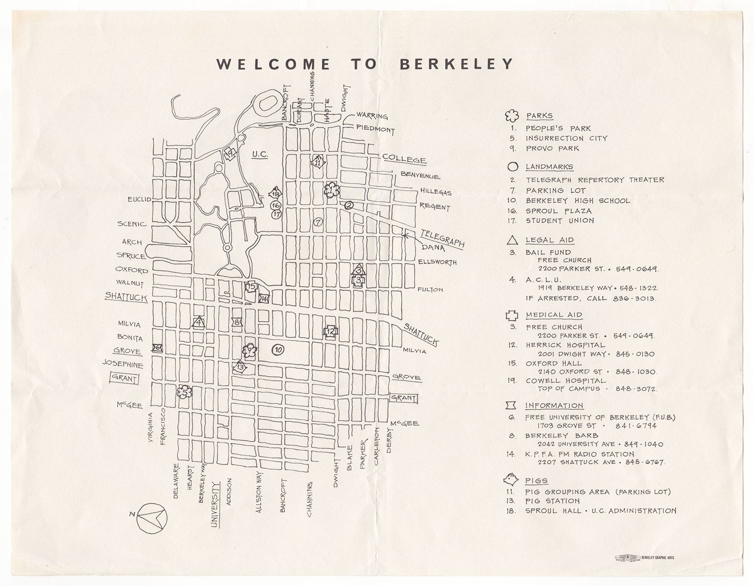
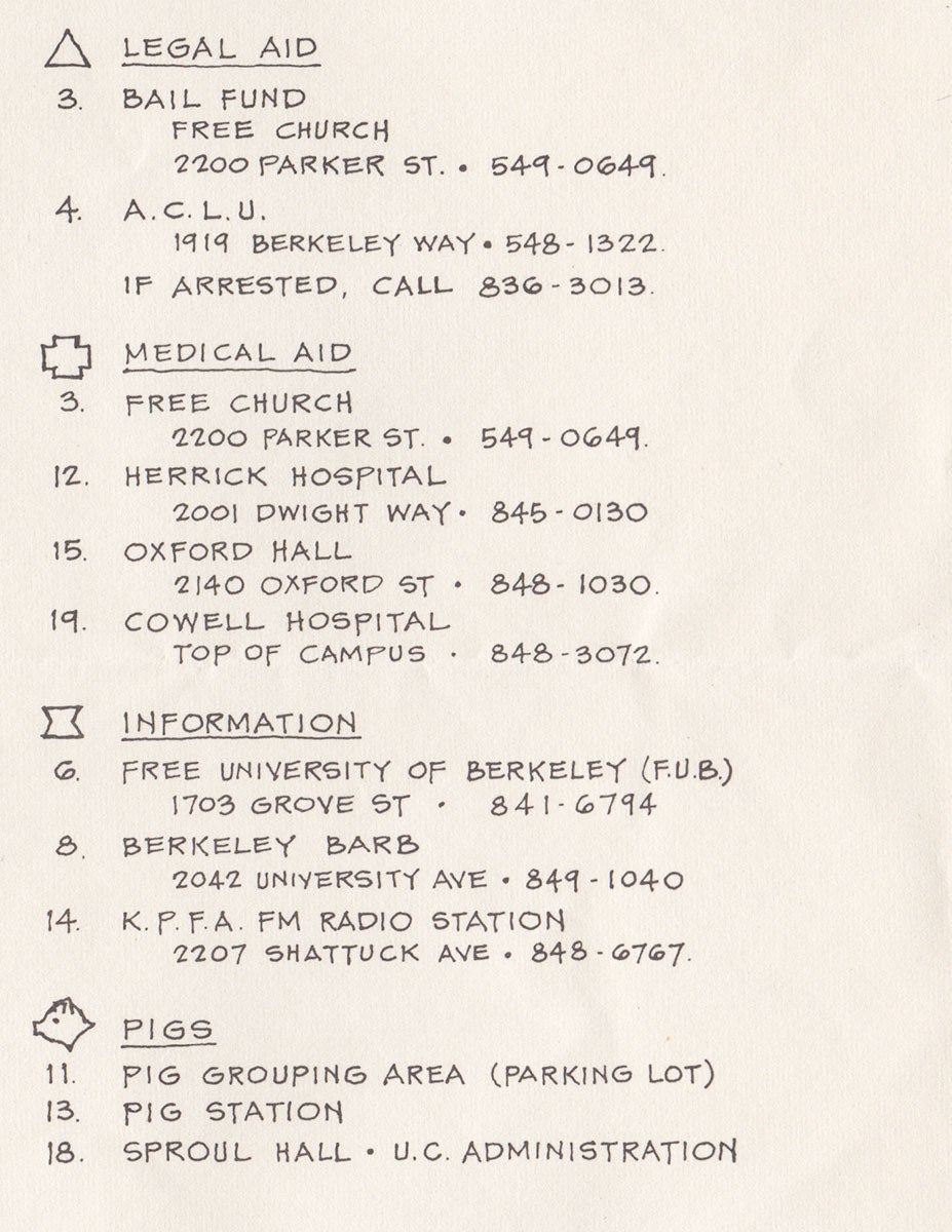
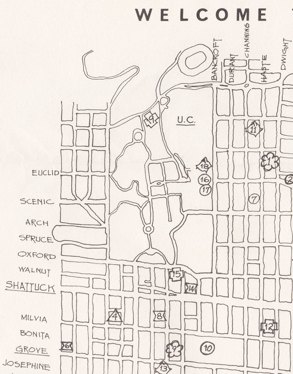
Berkeley, California: Offset Printing, Berkeley Graphic Arts, [1969]. 8vo (215 x 280 mm), black ink on white paper. A rare, highly ephemeral map produced during the People’s Park protests at UC Berkeley in 1969, featuring the campus, sites where demonstrators gathered, legal and medical sources of aid, the whereabouts of the police, and most notably People’s Park, which became a veritable battleground between the police and protesters. In 1956, the University of California bought a plot of land near UC Berkeley with residences on it, intending it for student housing and athletic fields. Demolition of the property began in February 1968, but the university ran out of development funds, leaving the lot only partially cleared. By May 1969, Berkeley students and local residents—some of them participants in the 1964 Free Speech Movement—had converted the derelict lot into a public park and free speech space. The university tolerated the activism by and large, although around this time it began construction on three-quarters of the park. Violent conflict arose and Gov. Ronald Reagan, who viewed the school as “a haven for communist sympathizers, protesters, and sexual deviants,” sent in the police—some armed with shotguns, which they initially used to fire birdshot but later loaded with “00” buckshot. On May 15— known as “Bloody Thursday”—a massive confrontation broke out between police and the activists. Student James Rector was shot and killed, and 128 protesters were hospitalized. Reagan declared a state of emergency and unrest continued for several weeks. Distributed during the protests, this map depicts the UC Berkeley campus and vicinity, and represents numerous locales of immediate interest to participants. A legend appears on the right and is subdivided into six parts: Parks, Landmarks, Legal Aid, Medical Aid, Information and—last but not least—Pigs, that is, the police as well as the UC Berkeley administration. People’s Park is listed as #1, along with #5 “Insurrection City” and #9 Provo Park. Next to an illustration of a pig’s head are #11 “Pig Grouping Area (Parking Lot),” #13 “Pig Station” and #18 “Sproul Hall - U.C. Administration.” Listed under Information are the addresses and phone numbers of the Free University of Berkeley (a student-run free speech organization and the likely creator of this map); the Berkeley Barb (an underground newspaper active from 1965–1980); and the KPFA (a local, listener-funded talk and music radio station). The various Landmarks denoted—including simply “Parking Lot”—were doubtless locales where protesters convened. Under the heading Legal Aid, the Berkeley A.C.L.U. and “Bail Fund” are listed along with their phone numbers. Beneath the A.C.L.U. listing, the text reads, “If Arrested, Call 836-3013.” This map is apparently unrecorded. No copies in OCLC, nor does a google search yield any trace of it. A rare and evocative “cartifact” of the People’s Park protest. PROVENANCE: This map was found in a lot of ephemera relating to People’s Park owned by Peter Marcuse (b. 1928), the son of Herbert Marcuse (1898–1979), the German-born social philosopher associated with the Frankfurt School of Critical Theory who immigrated to the U.S. in the 1930s and is regarded by many as the “Father of the New Left." CONDITION: Old folds and one small 30 mm crease in bottom right corner, otherwise very good.
REFERENCES: Jones, Lieutenant John E. History of People's Park at ucpd.berkeley.edu; Unforgettable Change: 1960s: People’s Park Fights UC Land Use Policy; One Dead, Thousands Tear Gassed at http://picturethis.museumca.org/
Item #4564
Sold