

Sign up to receive email notices of recent acquisitions.
An Account of Prince Edward Island, In the Gulph of St. Lawrence, North America. Containing Its Geography, a description of its different Divisions, Soil, Climate, Seasons, Natural Productions, Cultivation, Discovery, Conquest, Progress and present State of the Settlement, Government, Constitution, Laws, and Religion.
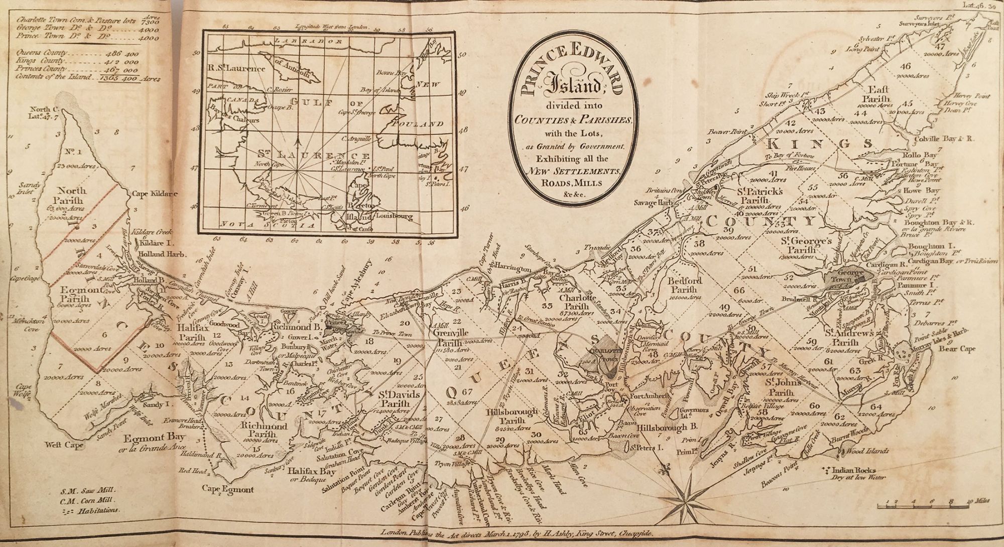
London: W. Winchester and Son, Strand, 1806. 8vo (20.7 x 13.5 cm), original full brown calf, gilt title label at spine. iii–xiii, [3], 1–304 pp. Folding map, 33 x 17 cm plus margins. Rare first edition of the first comprehensive history of Prince Edward Island during its early British colonial period, combined with an account of the Island’s natural history, resources, etc. Hailing from Scotland, John Stewart (1758–1834) was an army officer, politician, and author who effectively became Prince Edward Island’s first historian with the publication of the book offered here. Of particular interest today is Stewart’s account of the history of the colony during its early years and the politics in which he was frequently entangled. Also included are the first detailed descriptions of the Island’s topography, trees, animals, birds, fish, soil, natural productions, climate, and more. The folding map, bearing a publication date of 1793, depicts the counties and parishes, of P.E.I., as well as all the new settlements, roads and mills. It is based on Samuel Holland’s 1765 map of the region. Also included is an inset map of the Gulf of St. Lawrence and a table of acres. Stewart first arrived on P.E.I. in November 1775 with his father, Peter, who had recently been appointed chief justice of the colony. Noticeably, he makes no reference to the native Mi'kmaq people living on the island at the time. During the early British colonial period, it was customary to disregard the indigenous population whom the English settlers had by and large disenfranchised. CONDITION: Good, ex-library (deaccession confirmed) with early and largely inoffensive paper labels at spine and ink accession stamp of Vermont Historical Society on preface page, covers moderately worn, bookplate of one “Culver” on front paste-down, occasional light foxing; one front endpaper creased with a 2 cm loss to the lower right corner; map toned, lightly foxed, one small puncture, partial separation along one fold. REFERENCES: Sabin 91696; F. L. Pigot, “Stewart, John,” Dictionary of Canadian Biography, vol. 6 at biographi.ca
Item #4924
Sold