
Sign up to receive email notices of recent acquisitions.
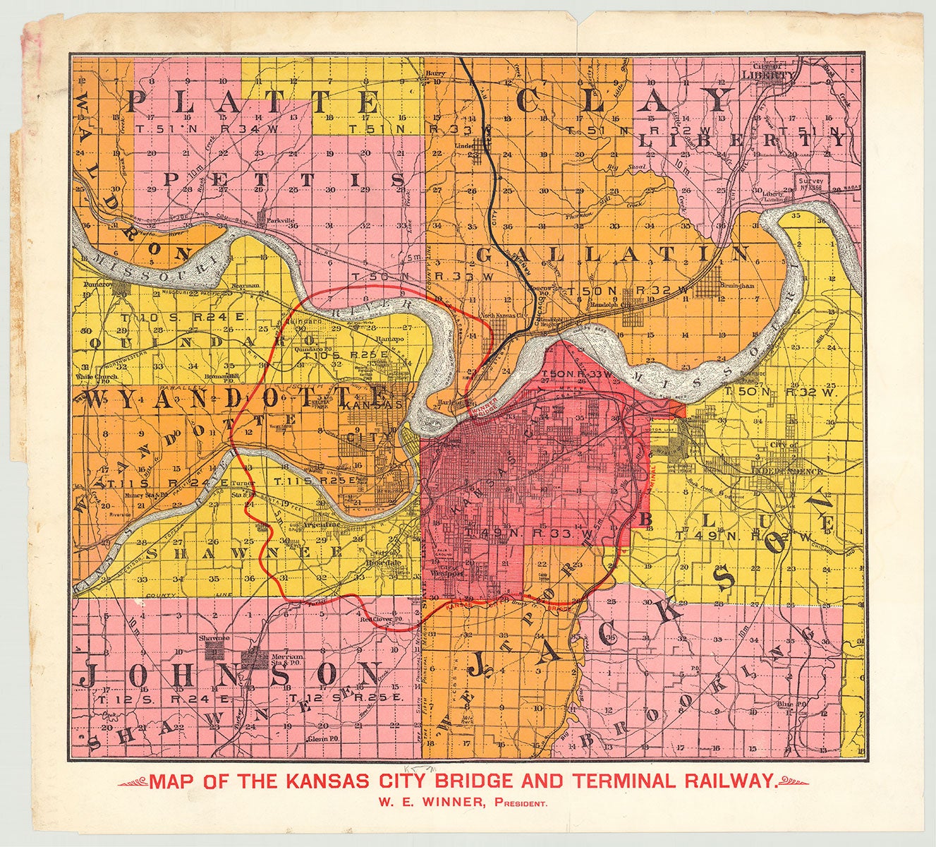
Map of the Kansas City Bridge and Terminal Railway.
Kansas City, Missouri, [ca. 1890]. Chromolithographic map, 14.75” x 16.75”, plus margins. A map of Kansas City and vicinity projecting the construction of developer Willard E. Winner’s bridge over the Missouri River and an associated railway. The “Winner Bridge” was the brainchild of Iowa-born Willard E. Winner (1849–1929) who moved to Kansas City around 1860 and by age twenty-six had built the city’s first electric streetcar line. This map highlights in red the projected location of the “Winner Bridge” across the Missouri River and a circuit running through Kansas City, Gallatin, Pettis, Quindaro, Wyandote, Shawnee, and Westport, identified as “Kansas City Bridge & Terminal.” While undated, this map was likely issued between 1887 and 1891 when the Winner Bridge was being contemplated and/or built. Work on the high-level truss Winner Bridge began in 1887, but the project was suspended in 1890 or 1891 after the piers were completed, when Winner went bankrupt. An alternate design for a lift bridge was proposed by noted civil engineer John Alexander Low Waddell, and work on that bridge—ultimately built as the Armour-Swift-Burlington Bridge by Armour, Swift and Burlington Co.—was begun in 1895 and completed in 1911. The bridge became the third built over the Missouri River at Kansas City. At the peak of his success, Winner’s investments embraced over 20,000 acres of real estate in Jackson, Platte, and Clay Counties. His fortunes shifted, however, during the 1890s when Kansas City’s real estate market collapsed, and by 1891 Winner was bankrupt. Winner had spent some four million dollars to build the present bridge to replace the ferry over to the North Kansas City area—where he envisioned plant sites and low-cost worker housing. Winner’s projected bridge was intended to connect his large properties in Clay County (some 10,000 acres, held by the North Kansas City Investment Co., which Winner formed)—making Clay County the Brooklyn to Kansas City’s Manhattan. Because only one bridge spanned the river at this time and carried rail traffic only, Winner began building another at his own company’s expense to enable vehicles and pedestrians to travel from Kansas City to these projected northern suburbs. However, his north side plan was flawed because the northern property was hard to sell before completion of his new bridge—and the bridge’s construction depended upon these very sales. When the bridge was abandoned its foundations lay open, and nine large piers—standing in the middle of the Missouri River—were hung with lanterns each night to prevent shipping accidents. Dying in poverty in 1929, Winner was a tragic example of Kansas City’s boom-to-bust economy of late nineteenth century—having made and then lost more money than any other man of his era. While Winner’s fall was fast, he nevertheless accomplished more than most during the speculative boom of the 1880s. What appears to be a tab in the upper left margin suggests that this map may have been part of a larger prospectus, or may simply have had paper covers, but we find no record of any related publication in OCLC, nor any copies of the map alone. REFERENCES: Coleman, Daniel. Missouri Valley Special Collections. Willard E. Winner; Creel, George and John Slavens. Willard E. Winner at vintagekansascity.com; Armour-Swift-Burlington Bridge at asce.org CONDITION: Some wear at margins, one small puncture in left-center, one old vertical fold.
Item #5519
Sold