
Sign up to receive email notices of recent acquisitions.
Strife For The Crown.
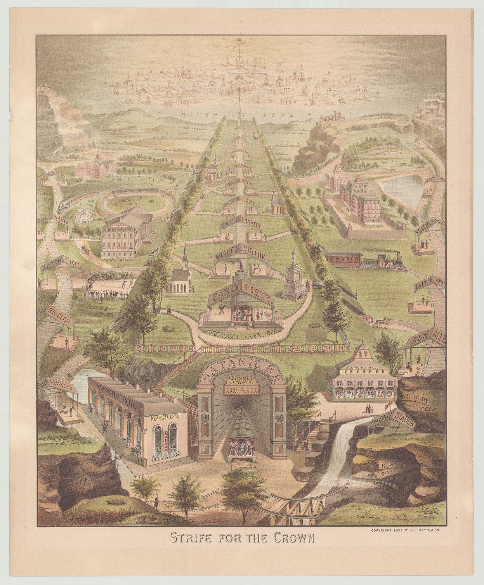
[New York?], 1891. Chromolithograph map, 17.75” x 15”, plus margins. An exceedingly rare pictorial and persuasive map vividly illustrating the divergent ‘railroad routes’ of good and evil, according to the teachings of Christianity. Comprising two alternative railroad lines, this map depicts life’s journey as either an ascent along the straight-and-narrow Eternal Life Railroad line, or a descent into hell via the Satanic Railroad line. Running on elevated land extending from the bottom to the top on a central line between hedges, the Eternal Life R.R. passes under numerous train station roofs bearing such labels as “Early Piety,” “Faith Charity,” “Godliness,” etc., and terminates in Heaven via a bridge spanning the River of Life. In the Kingdom of Heaven a beaming crown hovers in the clouds above numerous buildings. The Satanic R.R., by contrast, wanders about to the right and left of the Eternal Life R.R., taking its passengers to such stations as “Arson,” “Theft,” “God’s Wrath,” “Worldliness” “Idolatry,” “Rum Alley,” “Poverty Ville” and so on, ultimately descending into the “Tunnel of Death” at the center bottom. Near the tunnel’s entrance is “Murder Cave” as well as “Suicide Rock”—next to which a huge, terrifying snake (near a rock labeled “Sup’t Office”) hisses the word “LOST.” Numerous topographical details are featured, including rock-formations, hills, grassy areas, ponds, rivers, trees, and so forth. While the path of the Eternal Life R.R. is fenced-in by hedges, there are nevertheless opportunities to access its stations via various staircases throughout the realm of the Satanic R.R. Those choosing the path of the Satanic are shown visiting buildings and events. These include a circus, an insane asylum, a penitentiary, “robbers row” (which includes gambling, billiards, and a saloon), an alms house, a theatre, and so forth. Some of the activities along the Satanic R.R. include a boxing match; a racing track; a man pointing a gun at another man (near Murder Cave); scores of couples dancing at a dancing hall, etc. The only buildings along the Eternal Life rail-line are churches and one monument, entitled “Good Works.” While the original prototypes for “Paths to Heaven and Hell” maps were printed in Europe, a version was published in Baltimore circa 1795, likely by Samuel Saur. The genre was popularized, however, by two German American printers in Pennsylvania, Gustav S. Peters of Harrisburg and Herman William Villee in Lancaster. Another such map, The Way of Good & Evil, was published by John Hailer in Bath, Pennsylvania in 1862 (which can be viewed here: Hailer). However, while similar in concept, the present map differs markedly in its design from all of these these antecedents. No records in WorldCat; a Google search locates one copy, at the Library of Congress. A fascinating and imaginative map of moral instruction. REFERENCES: Earnest, Russell and Corinne. Flying Leaves and One-Sheets : Pennsylvania German Broadsides, Fraktur and Their Printers (New Castle, Delaware, 2005), pp. 252-9, illustrating earlier “Paths to Heaven and Hell” maps, with comments on the genre. CONDITION: Good, one light crease across lower section, another short crease, a few tiny chips at upper-left margin, tiny tears at right margin, a few light stains.
Item #5654
Sold