
Sign up to receive email notices of recent acquisitions.
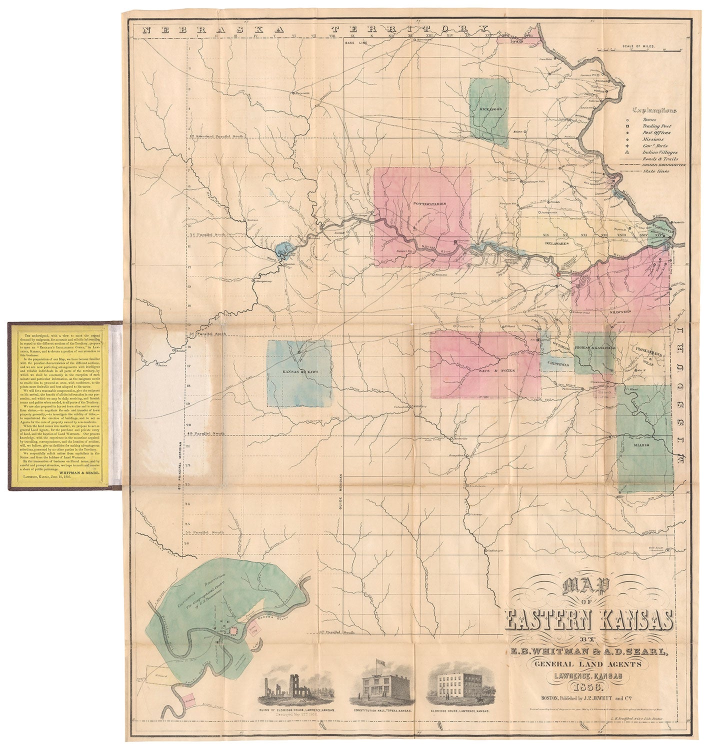
Map of Eastern Kansas by E. B.Whitman & A. D. Searl General Land Agents Lawrence, Kansas.
Boston: J. P. Jewett and Co.; lithographed by L. H. Bradford & Co., 1856. Hand-colored lithograph, 27” x 21” (sheet size), folding into original gilt-stamped burgundy cloth covers (6.25” x 4”), with title at front-cover, “Township Map of Eastern Kansas.” Printed text affixed to front pastedown, promoting Whitman and Searl’s land business, and dated 15 June 1856. CONDITION: Good, repairs and reinforcements to folds on verso, light wear. One of the most momentous maps of Kansas ever published and the most detailed map of Eastern Kansas of the period, published by several abolitionists in part to further the anti-slavery cause. Kansas Territory was created in 1854 through the Kansas-Nebraska Act which granted the settlers the right to decide whether to allow slavery within the two new territories. By the end of 1855, Kansas was inundated with violence between pro- and anti-slavery (or Free State) factions, and the territory became known as Bloody Kansas. The conflict resulted in the fall of the free-state town of Lawrence to pro-slavery forces in May of 1856. Published shortly afterwards, this map was created in an effort to encourage Free Soil settlers and speculators to immigrate to Kansas to counter similar efforts by slave states to move pro-slavery settlers into the territory. The map spans from a sliver of Nebraska Territory in the north to the abandoned Fort Scott in the south, and from Wyandotte, Kansas in the east to a portion of the Arkansas River in the west. Thirteen Indian reservations belonging to the Pottawatomies, Kickapoos, Shawnees, et al. are highlighted in either pink or blue and take up about a fifth of the map’s area—Native American lands that were jeopardized by the Kansas-Nebraska Act and the influx of settlers it brought. Depicted along the Kansas River at middle-right are three encampments of divisions of Shannon's Posse, dated 10 Dec. 1855, one of them opposite Lawrence. These were forces organized by pro-slavery Govenor William Shannon to quell what were deemed illegal activities by the anti-slavery faction. Also featured on the map are numerous creeks and rivers, roads (including the Santa Fe trail, and trails to California, Oregon, etc.), post offices, forts (both abandoned and in use), newly-established post offices, Indian villages, and towns including Lawrence (marked by a red circle and an American flag) and Topeka (both towns established in 1854), the latter identified as the “Temporary State Capitol.” In the lower-left corner is a large detailed inset of the Government Reservation at Fort Riley and its vicinity, identified as "The Geographical Centre of U.S. Possessions." Three vignettes are located in the lower margin: two images that depict a hotel before and after it was razed by pro-slavery forces during the sacking of Lawrence, and Constitution Hall in Topeka, Kansas. A key in the upper right corner identifies symbols for towns, trading posts, post offices, missions, forts, Indian villages, etc. In the text at the front pastedown, Whitman (a known abolitionist) and Searl promote their land business and offer emigrants a range of services to assist them in buying property. Lithographer Lodowick Harrington Bradford (1820–1885) was born in Boston and operated an engraving business there from 1845 to 1848. His partnership with Tappan lasted until Tappan’s death in 1854, after which Bradford continued as an engraver and lithographer under the name L. H. Bradford & Co., which existed from 1854 to 1859. While it is unclear if Bradford had any other partners, engraver George Girdler Smith is known to have worked for Bradford in the late 1850s, and was also a partner in various lithography firms associated with printing innovations and producing scientific illustrations. L. H. Bradford & Co. also produced scientific and other book illustrations, as well as views, maps, plans, and sheet music covers. Bradford’s best known prints are Fitz Henry Lane's largest and most successful lithographs, View of Gloucester, Mass. (ca. 1855) and Castine, from Hospital Island (1855). In 1856, Bradford began working with the Boston photographer James A. Cutting to create a photolithographic process, concentrating mainly on photolithography for the rest of his career. He died in Gloucester, Mass. in 1885. In addition to publishing the first edition of Uncle Tom’s Cabin in 1852, Boston publisher John P. Jewett (1814–1884) published a number of other anti-slavery works, including A North-side View of Slavery: The Refugee (1856), Anthony Burns: A History (1856) and History of the Oberlin-Wellington Rescue (1859). WorldCat records only one copy, at University of Missouri, Kansas City. A fascinating map of the tinderbox that was Kansas in the 1850s. REFERENCES: Baughman, Kansas in Maps, pps. 52-53; Pierce, Sally and Catharina Slautterback. Boston Lithography, 1825-1880 (Boston, 1991), pp. 128-130, 155; Streeter Sale, 3903.
Item #5753
Sold