
Sign up to receive email notices of recent acquisitions.
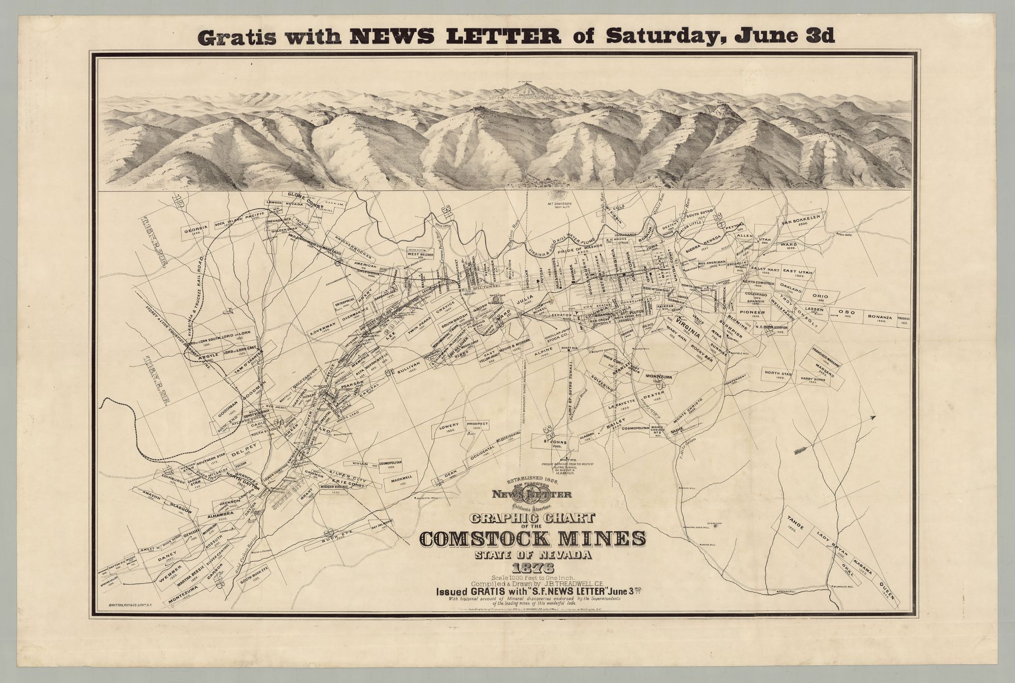
Gratis With News Letter of Saturday, June 3d…Graphic Chart of the Comstock Mines State of Nevada
San Francisco: San Francisco News Letter, 1876. Lithograph, 37.75” x 24.75” plus margins. Early note in ink on verso reading “If Mr Maloney that formerly was employed on board the cutter is now in Eastport he can explain this map to you he once worked in the “Gould & Curry” mine.”. A scarce and detailed map of Nevada's famed Comstock Lode silver mining district, including a bird’s eye view across the top depicting the same region. The Comstock Lode (named after miner Henry Comstock) was a rich silver ore deposit located under the eastern slope of Mt. Davidson, a peak in the Virginia Range in Virginia City, Nevada. The first major discovery of silver ore in the U.S., it attracted many prospectors from around the world after the discovery was made public in 1859. Mining camps in the vicinity thrived and developed into bustling commercial centers, such as Virginia City. A year before the present map was published Virginia City suffered a great fire that rendered 8,000 people homeless, with total losses estimated at $10 million. In less than a year, however, nearly everything was rebuilt. The Comstock Lode generated massive fortunes, the cash generated simulating the growth of Nevada and San Francisco, and helping to finance the U.S. government during the Civil War. Indeed, it has been speculated that the silver from Virginia City helped to save the Union. Peaking between 1876 and 1878, production at the Comstock mines declined sharply thereafter. After trying his hand at mining in Comstock, Samuel Clemens took a job at the Territorial Enterprise and began writing under the pen name Mark Twain—delivering news to Virginia City’s thriving metropolis of 25,000 inhabitants. Issued free of charge with the San Francisco News Letter (3 June 1876), this sheet features a bird’s eye view at the top depicting the extensive mountainous landscape of the region. The entrance to Sutro Tunnel and the development around it appear in the center foreground, while Mt. Davidson and Virginia City appear in the center background. In between is a mountain range that includes Mt. Kate, Mt. Rosa, Mt. Emma and Sugar Loaf. The map, showing the same region and drawn on a scale of 1000 ft. to the inch, depicts the multitude of mining claims, all numbered and identified by name, many of which are clustered in the ravine at bottom-left. Some properties bear colorful names such as “Buck Eye,” “Montezuma,” “Scorpion,” “Martha Bessie,” “Lord of Lorn,” “Tam O’Shanter,” and “Emigrant.” The grid representing Virginia City is very much part of the larger mining scene, with the names of claims superimposed on it and various mining shafts identified around town. Other features of the map include foundries, tunnels, graveyards, a water company’s reservoir, a hospital, cemetery, identified roads (and their various grades), the Virginia & Gold Hill Water Flume, an engine house, canyons, a toll house, ruins of buildings, ravines, etc. Numerous shafts and mills are colored black. The Virginia & Truckee R.R. snakes across the middle (a line that transported bullion from the rural highlands of Virginia City to Carson City). According to a note at the bottom, the issue of the June 3rd issue of the San Francisco News Letter featured a “historical account of Mineral discoveries endorsed by the Superintendents of the leading mines of this wonderful lode.” Joseph Britton (1825–1901) became a lithographer in New York, and at the time of the 1849 Gold Rush moved to California where he worked as a prospector for several years. Britton became a partner of Jacques J. Rey (1820–1892), who had studied lithography in Europe before coming to California himself in 1850. Britton and Rey’s partnership lasted four decades, Rey serving as the chief artist, while Britton worked as both a lithographer and artist, and handled the company’s business. Dubbed “the Currier & Ives of the West,” Britton & Rey were for a period the biggest producers of lithographs in California, their work providing an extensive visual history of California as it developed beginning in its early gold rush days. The firm lasted until 1915, when they were bought up by A. Carlysle & Co. Lithographer Joseph B. Treadwell was active from ca. 1870 to ca. 1890, and in 1875 published Treadwell's Bird's-Eye View of the Comstock Mines and Vicinity, Storey and Lyons Counties, State of Nevada. OCLC records just five copies. REFERENCES: Not in Reps. Last, Jay. The Color Explosion : Nineteenth-Century American Lithography (Santa Ana, CA, 2005), p. 45; History at visitvirginiacitynv.com CONDITION: Very good, light wear, old folds now flattened, minor paper pulp reinforcement on verso to sections of a few folds.
Item #6377
Sold