
Sign up to receive email notices of recent acquisitions.
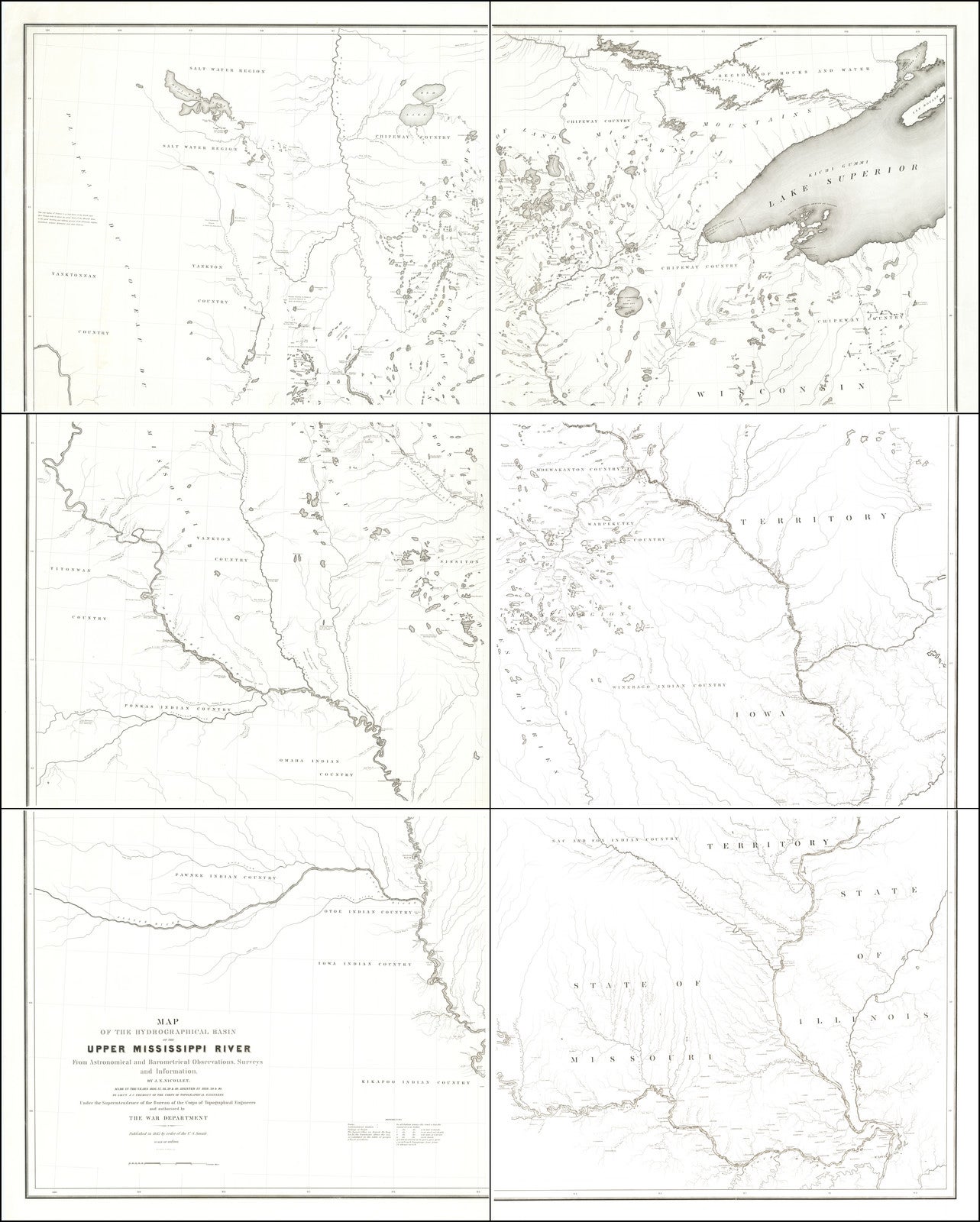
Map of the Hydrographical Basin of the Upper Mississippi River From Astronomical and Barometrical Observations, Surveys and Information. By J. N. Nicollet. Made in the years 1836, 37, 38, 39 & 40. By Lieut. J.C. Fremont of the Corps of Topographical Engineers Under the Superintendence of the Bureau of the Corps of Topographical Engineers and authorised by The War Department Published in 1842 by order of the U.S. Senate.
Washington, D. C.: United States Senate, 1842. Engraving on six sheets, 62 x 76.5 inches overall. Center right and lower right sheets in facsimile. The exceptionally rare six-sheet Nicollet & Fremont map of the upper Mississippi River, considered the foundation of modern mapping of the Upper Midwest and Great Plains and “One of the most important contributions ever made to American geography.” (Gouverneur Kemble Warren). Nicollet’s map depicts the Mississippi Basin from just below the mouth of the Missouri all the way to roughly 48° 30’ north latitude; in all, an enormous region encompassing all or part of the present-day states of Illinois, Iowa, Kansas, Minnesota, Missouri, North and South Dakota, and Wisconsin, as well as the southern reaches of Manitoba and Ontario. Befitting the title, Nicollet provides groundbreaking detail of the complex of lakes and rivers feeding the Upper Mississippi (Among other things, it is the first published map to name Lake Itasca, the source of the Mississippi.) The map also locates American settlements and towns and the territories of native peoples—taking great care with the toponymy of the latter, delineates “portages” and “routes”, and offers dozens of interesting geographical and ethnographic notations.
Reflecting the care Nicollet brought to his work, asterisks indicate hundreds of locations at which astronomical observations were made, these being essential to fixing control points that provided a precise geographic framework for the map. Three- and four-digit numerals indicate altitudes established by barometric observation, an imperfect method but far better than anything previously attempted in the region. To get a sense of the map’s excellence, compare it with Map of the Route passed over by an Expedition into the Indian Country in 1832 to the Source of the Mississippi, based on Henry Schoolcraft’s expedition to the source of the Mississippi and, prior to Nicollet’s, the finest map of the region.
Since soon after its publication, Nicollet’s map received glowing endorsements. 19th-century cartographer Gouverneur K. Warren hailed it as “one of the greatest contributions ever made to American geography.” (Holland, p. 115) More recently, Schwartz and Ehrenberg comment that “Nicollet’s map initiated the scientific mapping of the trans-Mississippi West by the War Department.” (p. 268), while Rumsey describes the map as “years ahead of its time, with its regional concept and sound basis in instrument readings and astronomically determined points.” (Rumsey #2488)
The three Western expeditions of Joseph Nicholas Nicollet
Nicollet (1786-1843), was a French scientist, geographer, and mathematician, sufficiently eminent that in his thirties he had received the Legion of Honor. After suffering financial ruin in the 1830 collapse of the French stock market, he emigrated (“fled” may be more accurate) to the United States and launched a career as one of the greatest explorers of his adopted homeland. Once in America he formed a connection with Ferdinand Hassler, head of the U.S. Coast Survey, who encouraged him in his vision of a “scientific tour” to explore and map the Upper Mississippi.
Nicollet eventually made three such “tours”. The first, purportedly funded by the American Fur Company and the powerful Choteau Family of St. Louis, took him in 1836-37 to the upper reaches of the Mississippi. On the strength of this first success, in 1838 he was tapped to lead the first expedition of the newly-formed Corps of Topographical Engineers and charged with exploring the vast region between the Mississippi and Missouri Rivers. Accompanying him was, among others, John C. Fremont, who assisted in many of his astronomic and geographic observations. Finally, in 1839, again with Fremont, he followed the Missouri River to Fort Pierre (in present-day South Dakota) then traveled overland to Devils Lake (North Dakota).
Incidentally, Nicollet and Fremont seem to have got on famously. His opinion perhaps influenced by the luxurious provisioning arranged by Nicollet (including canned sardines and chocolate from Delmonico’s), Fremont later wrote:
“I could not dwell too much upon [Nicollet’s] superb management of the expedition…. not an article lost or broken throughout our long journey… not a horse injured or stolen, a set of the most ungovernable men in the world reduced in less than a week to perfect order & obedience.” (Cohen, p. 124)
Nicollet returned to Washington on September 11, 1839. There he worked on compiling this map, “based on ninety thousand longitude and latitude readings, on altitudes measured with barometers, and on the accumulation of a wealth of other geographical data that filled sixty-seven manuscript map sheets” (Holland, p. 113) The result was this map on six sheets, which dramatically improved the cartography of the region, and was published by order of the U.S. Senate in 1842. In 1843, a report was published with a much-reduced edition of the map, featuring topographical detail not included in the first edition.
Nicollet died of cancer in 1843 before he could return to continue his work in Minnesota and on the Plains as he had planned.
Rarity and references
We obtained the four sheets offered here in 2019, in a remaindered group of XX sheets, none sufficient to complete the six-sheet map. The map has otherwise traded only once in recent history, at Swann Galleries in 2006, where a complete six-sheet example sold to the trade for $59,800. OCLC records nine examples, at the Abraham Lincoln Presidential Library, Dartmouth, Fargo Public Library, Harvard, Massachusetts Historical, New York Public, UCLA, University of Wisconsin-Milwaukee, and Yale. Many of these institutions likely received the publication in their capacity as government depositories.
Rumsey #2488 (2nd ed. of 1843). Martha Coleman Bray, Joseph Nicollet and His Map (Philadelphia: American Philosophical Society, 1980). Paul Cohen, Mapping the West (New York: Rizzoli, 2002), pp. 122-125. Robert Holland, The Mississippi River in Maps and Views (New York: Rizzoli, 2008), pp. 112-115. Seymour Schwartz and Ralph Ehrenberg, Mapping of America (Edison, NJ: Wellfleet Press, 1980), pp. 267-269.
Item #6612
Sold