
Sign up to receive email notices of recent acquisitions.
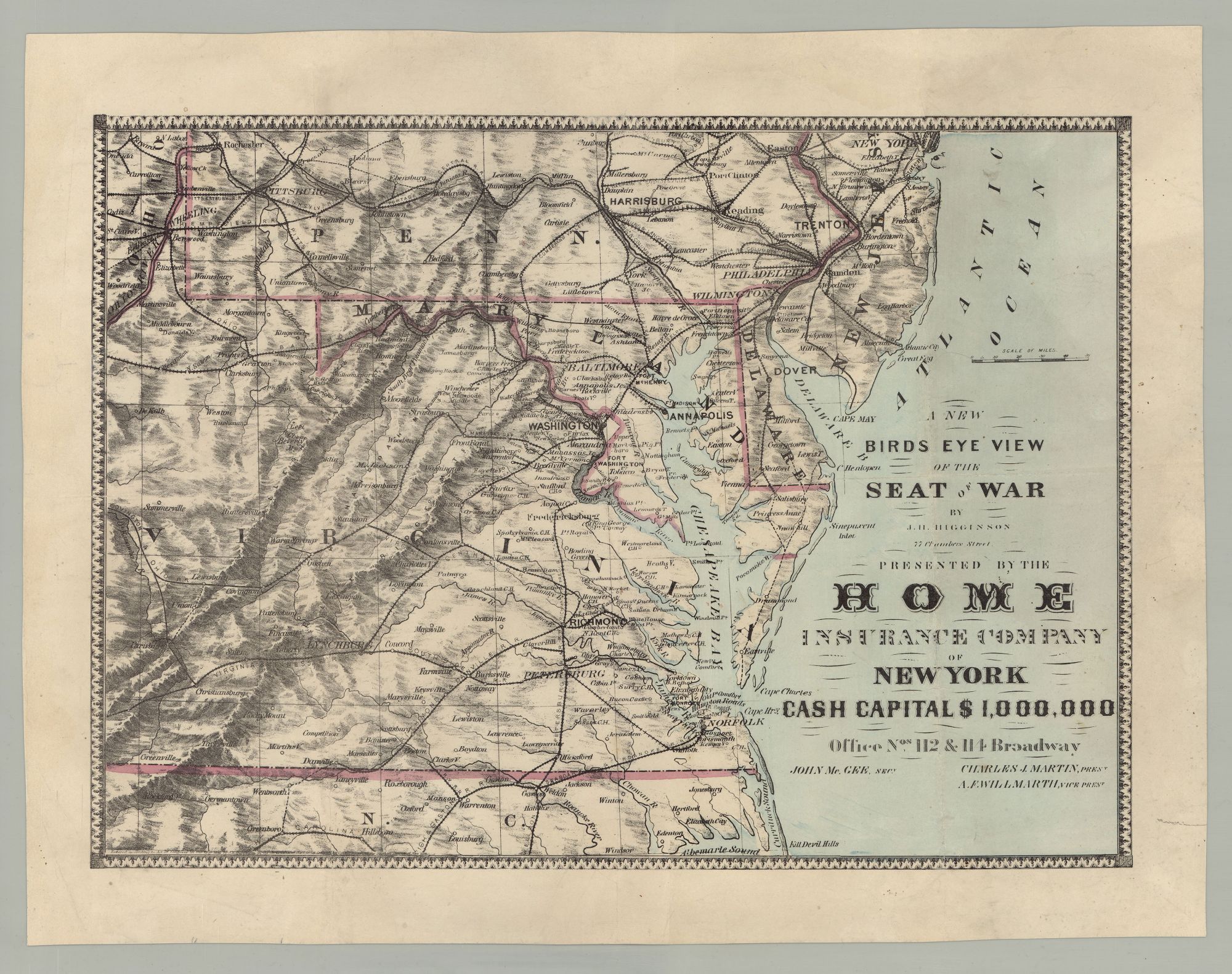
A New Birds Eye View of the Seat of War…Presented by the Home Insurance Company of New York Cash Capital $1,000,000.
[New York]: Home Insurance Company, 1861. Hand-colored lithograph, 13” x 18”, plus margins. CONDITION: Very good, light wear. A scarce map of the seat of the Civil War, advertising one of America’s largest fire insurance companies of the nineteenth century, compiled by a New York City mapmaker who seems to have partly specialized in maps for the insurance industry. This map spans from North Carolina in the south to Manhattan in the north, and from the eastern seaboard to Ohio, covering Virginia, Maryland, Washington, D.C., and Delaware, as well as parts of Pennsylvania, New Jersey, New York, Ohio, and North Carolina. It includes state and county boundaries, towns, cities, mountain ranges, and railroads. Among the railroads depicted are the Virginia & Tennessee R.R., the Richmond & Danville R.R., and the Cumberland Valley R.R. Relief is shown by hachure and the map is set within an ornamental border. The addresses of the Home Insurance Company’s New York offices on Broadway St. and the names of the company’s secretary, president, and vice president appear in the lower right corner. Founded in 1853, the Home Insurance Company (HIC) was by the time of the Civil War one of America’s largest fire insurance companies. Roughly one-third of the company’s policies covered southern property owners. During and after the war, HIC honored all policies, in both the north and the south. By 1861, as noted here, its capital reserve was one million USD. Despite setbacks during the Civil War, HIC continued to increase its customer base, premiums, and capital reserve—the present promotional map being indicative of the company’s attempt to forge ahead despite the war and the obstacles it posed. By 1864, they increased their capital reserve again, to two million USD, thereby becoming the largest fire insurer in the country. Following the Great Chicago Fire, the national fire insurance industry was transformed. Many of the proactive measures instituted at HIC contributed to the development of the modern insurance industry. In 1991, HIC was purchased by TVH Acquisition Corporation. Mapmaker and publisher J. H. Higginson was active in New York in the 1850s and 1860s. He produced a number of maps over the course of a decade or so, and appears to have served as something of a mapmaker to the insurance industry. His output includes Map of the City of Newark, N.J. (1858); New Map of the City of Brooklyn as consolidated by an act of the legislature of the State of New York (1859); Higginson's Map of Europe : comprising Sardinia, Switzerland & Italy, with a large part of France & Germany (1859) for the Home Fire Insurance Company; The Seat of War North Italy (1859) for the Home Life Insurance Company; A New Military Map of the Seat of War (1861) for the Market Fire Insurance Company of New York; and Map of the Seat of War in Europe (1870) for the Home Insurance Company, among others. WorldCat records three copies, at the Peabody Essex Museum, Harvard University, and the Library of Congress. REFERENCES: Stephenson, Civil War Maps 449.8; Tooley's Dictionary of Mapmakers, E–J, p. 330; The Home Insurance Company at encyclopedia.com
Item #6768
Sold