
Sign up to receive email notices of recent acquisitions.
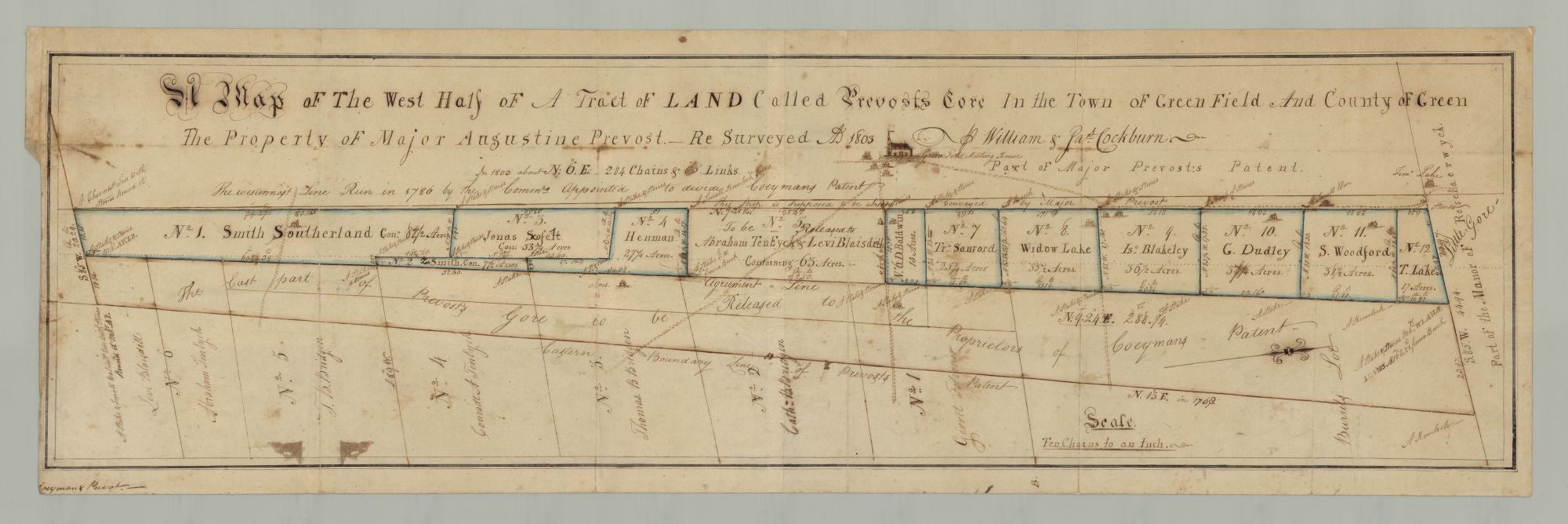
A Map of the West Half of a Tract of Land Called Prevost’s Gore in the Town of Green Field and the County of Green The Property of Major Augustine Prevost. Re Surveyed AD 1803. Part of Major Prevost’s Patent.
Green Field [today’s Greenville], New York, 1803. Ink and watercolor outline on two joined sheets of wove paper. Image size 8.75 x 30.9375 inches; sheet size 9.875 x 31.375 inches. CONDITION: Very good, old folds, minor stains, a few expert paper pulp repairs on verso to separations at folds, etc. A manuscript map depicting land in Greenfield, New York belonging—or once belonging—to Major Augustine Prévost III, formerly a British officer during the Revolutionary War and a prominent Greene County citizen and landholder. This detailed survey of a strip of land known as Prevost’s Gore, drawn on a scale of “ten chains to an inch,” focuses on the western half of the gore, which is divided into various plots, each numbered and bearing the number of acres and the name of a landowner or landowners (to whom Prévost must have previously sold the land, in spite of the map title’s suggestion to the contrary). Those named are Smith Southerland, Z. Smith, Jonas Scoflet, Henman, Abraham Ten Eyck & Levi Blaisdell, D. Baldwin, Trn. Sanford, Widow Lake, Isc. Blakely, G. Dudley, S. Woodford and T. Lake. A note in plot No. 5 reads “To be released to Abraham Ten Eyck & Levi Blaisdell. Containing 63 acres.” Sketches of buildings appear in seven of the plots as well. A narrow strip immediately adjacent to the western side of the gore carries a note reading “This strip is supposed to be already conveyed by Major Prevost.” The eastern side of the gore carries a note reading “The East part of Prevost’s Gore to be Released to the Proprietors of Coeyman’s Patent.” Lending considerable charm to the map is a sketch in the title area showing the Greenfield Meeting House with four houses clustered nearby, evidently constituting what would have been the village of Green at the time. Other details include various notes identifying such landmarks as “A Chesnut Tree with stones round it,” “a stake & small walnut tree with stones,” and so on. Augustine Prévost III (1743-1821) of Greenfield, New York, the son British army officer Major Augustine Prévost (1723-1786), served in America just after the French and Indian War and during the Revolutionary War. The Prévost family were French Huguenots who, by the 16th century, had established themselves in Geneva, Switzerland. Several generations of Prévosts served in the British army. Augustine Prévost III was Major in the 60th Foot, Royal American Regiment, Deputy Inspector-General and Adjutant. Following the Revolution, he remained in America, settling on 3000 acres in New York that his father had been granted by the Crown for his service in the French & Indian War. In spite of the Revolution, Prévost III was able to retain the grant as a result of his friendships with such influential Americans as Aaron Burr, Alexander Hamilton, John Jay, and others. An appealing manuscript map reflecting the role of a significant Greene County landholder in the history of land ownership and development in the region. REFERENCES: Prevost Family Papers (1764-1924) online at the Albany Institute.
Item #6787
Sold