
Sign up to receive email notices of recent acquisitions.
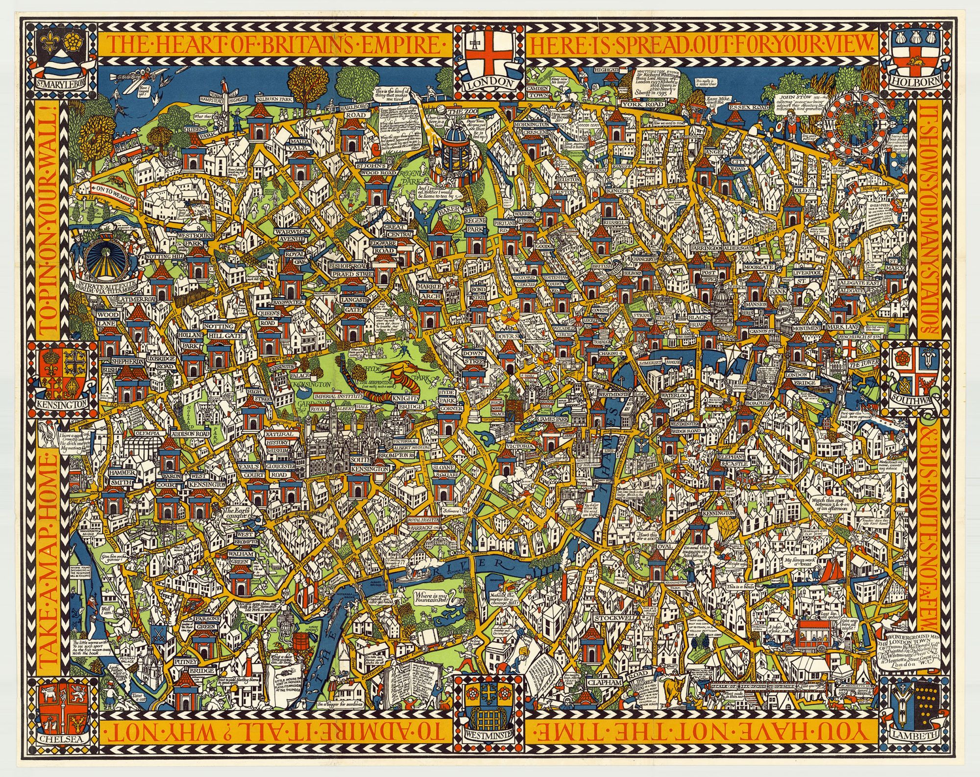
The Wonderground Map of London Town.
London: Printed and Published by the Westminster Press, 11 Henrietta Street, Covent Garden, [1927]. Pictorial map printed in full color, 29” x 36.5” plus margins. CONDITION: Very good, old original folds. MacDonald Gill’s iconic and foundational pictorial map of London and its underground railways. This is the third of three states of this map, indicated by the greyhound in the upper-left, located in the triangle of land above the sign reading "On to Wembley." Houses appear in the same triangle in the first state (1914), and a lion supplants the houses in the second state (1924). The map depicts the city of London peopled with individuals making quips and puns about roads or place-names. Men hurl hams in Hurlingham; in Earl’s Court “the Earl’s caught!”; on the Harrow Road a farmer tilling the soil cries, “Harrowing work, this!” (an utterance countered by the query of a gentleman nearby, “What is work, is it a herb?”), and so forth. A sign placed at the map’s eastern border points in the direction of “Victoria Park, Wanstead Flats, Harwich, Russia and other villages”; a serpent has taken up residence in the Serpentine, etc. Motor cars and B-Type buses drive through the city, and a monoplane crosses the skies above. Incorporated into the border is promotional text reading “The heart of Britain’s empire here is spread out for your view. It shows you many stations & bus routes, not a few. You have not the time to admire it all? Why not take a map home to pin on your wall!” In May 1914, the Daily Sketch claimed that “People spend so long looking at this map—they miss their trains yet go on smiling.” London was the world’s first city to have an underground subway system, its first underground train-line beginning service in 1863. By 1913, the London Underground was broadly considered dysfunctional and reached a critical juncture. The Underground’s commercial director, Frank Pick called for “some eye-catching posters, distinct from general advertisement bills, that will make Londoners of all social classes proud to journey around their city and visit its attractions.” The “Wonderground Map,” as Londoners came to call it, attained such popularity that it was sold for homes and offices. The map is now credited with having saved the Tube. This map influenced numerous 20th century mapmakers and sparked a colorful period of pictorial mapmaking internationally. Mapmakers around the globe were inspired to create ‘Wonder’ maps of their own cities, including Melbourne, Mexico City and Barcelona. Born in England, MacDonald “Max” Gill (1884–1947), the younger brother of famed artist and typographer, Eric Gill, is often credited with the revival of the decorative map. In the early 20th century, Gill’s poster maps were used in major publicity campaigns for a range of British institutions. In 1913, Gill discussed with Frank Pick the idea of a pictorial poster map that would entertain passengers as they waited for trains on station platforms. The map first saw publication in 1914, and Pick would later commission Gill to design a new London Underground system map. During WWI, Gill worked as an architect and designed the alphabet for the British military headstone, which is still in use today. Among the numerous poster maps he created in the 1920s, during the peak of his career, was Highways of Empire (1927), a hemispherical projection of the world. Constituting the largest poster ever produced up to that time, the map was the first of eight posters Gill created for the newly-formed Empire Marketing Board. A wonderfully entertaining and historically notable pictorial map. REFERENCES: Marshall, Colin. “The Wonderground Map of London Town,” the Iconic 1914 Map That Saved the World’s First Subway System at openculture.com; Walker, Caroline and Andrew Johnston. The Life and Legacy of MacDonald Gill at bl.uk.
Item #7068
Price: $3,500.00