
Sign up to receive email notices of recent acquisitions.
Millions of Acres, Comprising Many of the Best Prairie Lands in Iowa & Nebraska For Sale by the Burlington & Missouri River Railroad Company, on Ten Years Credit, at 6 Per Cent. Interest.
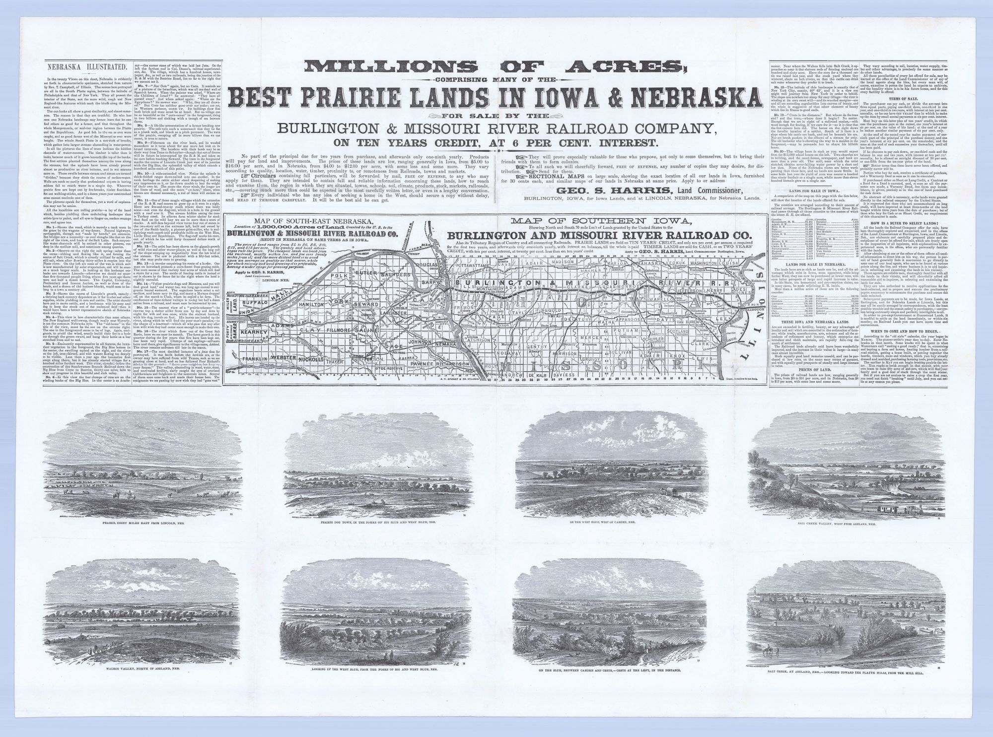
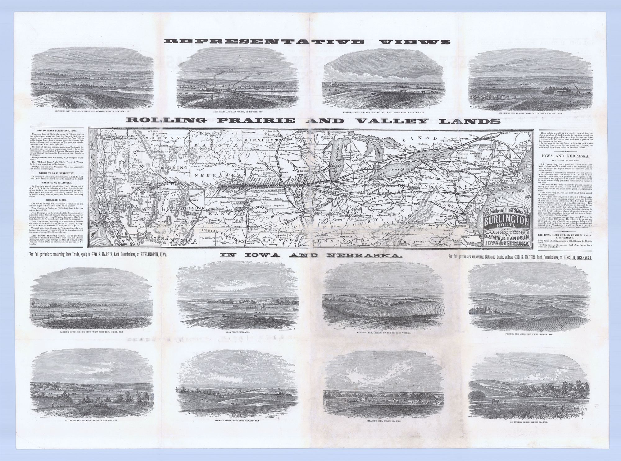
[Chicago]: Burlington & Missouri River R.R. Company, [1872]. Illustrated broadsheet with inset maps, 21.5” x 31.25” (printed area); 24.375” x 33.125” (sheet size); 2 maps and 20 wood engraved views. A broadsheet advertising prairie and timber lands in Iowa & Nebraska offered by the Burlington & Missouri River Railroad, issued shortly after it was joined with the Union Pacific at Kearney, thereby connecting southeastern Nebraska with the broader continental rail network. This appealing broadsheet features extensive text and no fewer than twenty illustrated vignettes of Nebraska lands. It was issued to advertise a whopping 1,500,000 acres of railroad land for sale in southeast Nebraska and southern Iowa, all within a twenty-mile limit of the Burlington & Missouri’s route. The map on the recto shows the transcontinental railroad network, thus emphasizing that the lands for sale offered excellent access to coastal markets. The verso map shows the route of the Burlington & Missouri in southern Iowa and southeast Nebraska. Also shown are spur lines serving the lands on offer. The twenty-mile limit is delineated along both sections of railroad. Counties, towns, and rivers are shown as well. The twenty inset Nebraska views “present the interior of the State, not the more wild, rough and New England-like features which mark the bluffs along the Missouri River.” They depict rolling prairies and valley lands, farmers at work, grazing cattle, trains passing through, factories, corn fields, individuals on horseback, wagons, and so on. Much of the accompanying text is given over to describing each vignette at considerable length. The text on the verso also addresses practical matters such as how to reach Burlington, Iowa; where to go in Burlington and Lincoln, Nebraska for assistance in securing lands; railroad fares, etc. Interested parties are instructed to apply to Geo. S. Harris, Land Commissioner in Burlington for circulars containing all the particulars of the lands on offer—which are provided free of charge. Those venturing west are urged to bring their friends to form colonies. The terms of sale stipulate payment of only “six per cent per annum… for the first two years, and afterwards only one-ninth yearly, with interest on balances, till the whole is paid.” Prices of prairie land in Nebraska range from $4 to $12 and in Iowa from $5 to $16, with prices varying according to land quality, water, timber, and proximity to railroads, towns, and markets. Cheaper lands are located further from the railroad, mostly within ten miles but some located twenty miles out. The more distant lands are described as superior for stock raising and wool growing, with a wider range for grazing purposes. In contrast to prairie lands, timber lands were available for cash or on two years’ credit, with ten per cent interest, “at twenty per cent less than on ten years’ credit.” The Burlington & Missouri River Rail Road was founded in Burlington, Iowa in 1852 to construct a railroad across the state. In November of 1859 the Iowa section of the railroad was completed when it reached the Missouri River. A branch of the railroad was incorporated in Nebraska in 1869, and construction from Plattsmouth to Lincoln began in July of 1870. Congress granted the Railroad alternating sections (mile-square parcels) extending twenty miles north and south of the route, which the Railroad was then responsible for selling to settlers and investors. This was in keeping with the Federal strategy of providing western railroads with massive land grants: The sale thereof would fund construction and operations while engaging the railroads as the government’s de facto agents in encouraging western settlement. The railroad connected with the Union Pacific in 1872 and a vigorous advertising campaign was begun the same year, of which the present broadsheet was a part. WorldCat records five copies, at the Newberry Library, University of Utah, Wisconsin Historical Society, Yale, and SMU. Not in Modelski, Railroad Maps of the United States. In all, a rare and visually engaging promotional issued at an important moment for the settlement of southeastern Nebraska. REFERENCES: Burlington and Missouri River Railroad. Railroad Structures at history.nebraska.gov; The Burlington and Missouri River Railroad at mynehistory.com. CONDITION: Toning to two panels, with mends, restoration and reinforcement to separations and minor losses along folds. Offered in partnership with Boston Rare Maps of Northampton, Mass.
Item #7083
Sold