
Sign up to receive email notices of recent acquisitions.
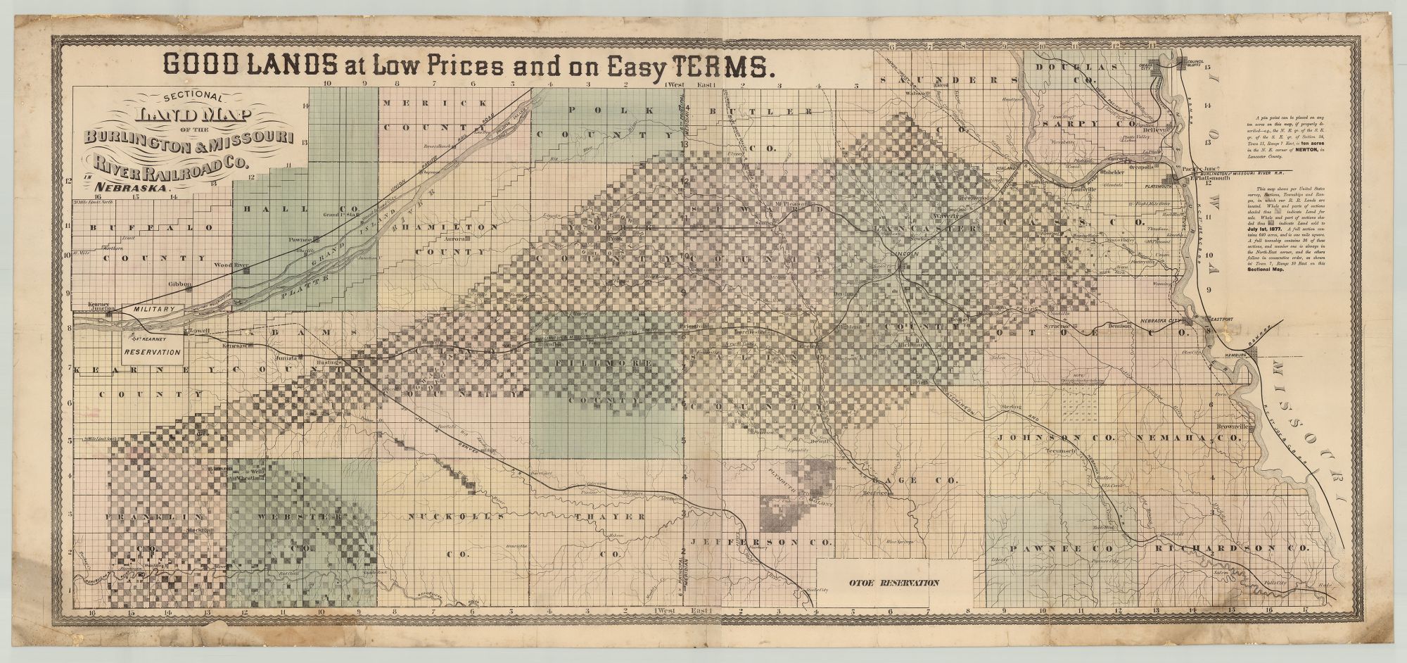
Good Lands at Low Prices and on Easy Terms. Sectional Land Map of the Burlington & Missouri River Railroad Co. in Nebraska.
[St. Louis, Missouri: August Gast & Co., lithographer, 1877]. Hand-colored lithograph, 23” x 51” plus margins. Recently backed with linen. CONDITION: Good, moderate staining to margins and a few small portions of the map, margins lightly chipped, red and orange coloring largely faded. An unrecorded map of southeastern Nebraska showing the Burlington and Missouri River Railroad and associated company lands both for sale and recently-sold. This map shows the section of railroad running from Plattsmouth in the east to Kearney Junction in the west and a number of connecting rail lines such as the Atchinson and Nebraska R.R. and Omaha & Southwestern. Lands for sale by the railroad company are concentrated in the center, with additional lands in the southwest corner. They are variously shaded according to their availability (some of the land had been sold as recently as July 1st, 1877). A full square of land contains 640 acres and is one square mile. Other details include towns and cities, variously colored Nebraska counties, roads, rivers, mountains, Fort Kearney (est. 1848) and its surrounding military reservation, railroad junctions, as well as railroads completed, under construction, and proposed. The Burlington & Missouri River Railroad Company was founded in Burlington, Iowa in 1852 to construct a railroad across the state. In November of 1859 the Iowa section of the railroad was completed when it reached the Missouri River. A branch of the railroad was incorporated in Nebraska in 1869, and construction from Plattsmouth to Lincoln began in July of 1870. Congress granted the Railroad alternating sections (mile-square parcels) extending twenty miles north and south of the route, which the Railroad was then responsible for selling to settlers and investors. This was in keeping with the Federal strategy of providing western railroads with massive land grants: the sale thereof would fund construction and operations while engaging the railroads as the government’s de facto agents in encouraging western settlement. The Burlington & Missouri connected with the Union Pacific in 1872 and a vigorous advertising campaign was begun the same year, of which the present map was a part. Although the map lacks a printer’s credit, a slightly later version printed by August Gast (1819–1887) is known. August and his brother Leopold Gast were born in Germany and emigrated to the U.S. after learning the lithographic trade. Settling in St. Louis in 1849, the brothers established a lithography firm in 1852. During the early 1860s, Leopold ran the company while August worked at McKittrick & Co. In 1866, August bought out Leopold’s share of the company and continued to run the firm with various partners, creating advertising posters, city views, labels, trade cards, and lithographs for the railroad. Following August’s death in 1887, the company was reorganized as the Gast Bank Note & Lithographing Co., which specialized in printing for financial institutions and operated until 1975. Not in OCLC, which records only a single example of the slightly later version showing lands for sale and lands sold January 1st, 1878. REFERENCES: Last, Jay. The Color Explosion: Nineteenth-Century American Lithography (Santa Ana, CA, 2005), pp. 82–83; “Burlington and Missouri River Railroad. Railroad Structures” at History Nebraska online.
Item #7091
Sold