
Sign up to receive email notices of recent acquisitions.
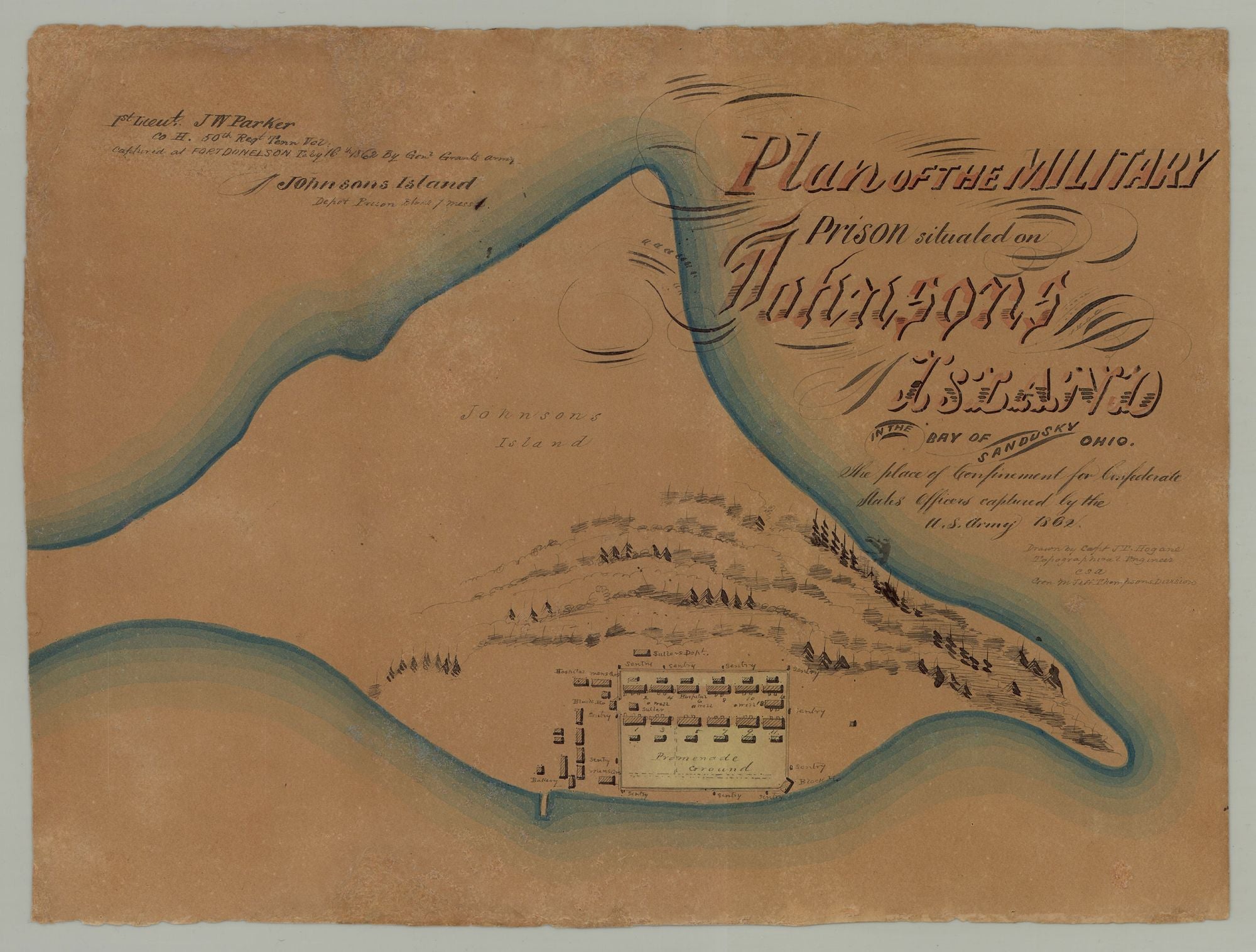
Plan of the Military Prison Situated on Johnson’s Island in the Bay of Sandusky Ohio. The place of confinement for Confederate States Officers captured by the U. S. Army 1862.
Johnson’s Island, Sandusky Bay, Ohio, 1862. Manuscript map in ink and watercolor on wove paper, 9.625” x 12.875”. CONDITION: Very good, light chipping at margins, a few light spots of discoloration and scuffing. A rare manuscript plan of the Civil War prison on Johnson's Island in Sandusky Bay, Ohio, by a Confederate officer imprisoned there, created for a fellow inmate whose name, date of capture, etc. are inscribed in the upper-left. The map shows Johnson's Island in its entirety and includes a plan of the prison, located on the southwestern end of the island. Likely due to his imprisonment, Hogane seems to have had minimal understanding of the contours of the island, as its shape as depicted here bears little resemblance to its actual more elongated shape. The representation of the prison itself, with which Hogane would have been more intimately familiar, is quite detailed. Depicted within the prison are the thirteen numbered buildings that housed the prison population, one of which (#6) served as a camp hospital; adjacent to these buildings are latrines, mess halls, and so forth. Also shown within the prison are multiple wells, a promenade ground (occupying a third of the prison area itself), and a sutler, who sold items to the prisoners (some prisoners received money from family members and friends). Surrounding the prison are numerous sentries, and just outside its walls are a hospital, sutler’s depot, a bakery, block houses, two men’s quarters (which presumably housed the 128th Ohio Volunteer Infantry, assigned to prison guard duty for most of the war), and a range of other buildings. A wharf near the bakery juts out into the bay, and on the outskirts of the prison are numerous trees. The island’s shores, parts of the prison, and the map’s ornamental title are colored. A presentation inscription appears in the upper left corner, reading: “1st Lieut. J. W. Parker Co. H. 50th Regt. Tenn. Vol. Captured at Fort Donelson Feby 16th 1862 by Genl Grant’s army. Johnson Island Depot Prison Block 7 mess 1.” John W. Parker (1836–1880?) of Murfreesboro, TN married Mary L. Aslin in 1859 and worked as a brick mason before the war. Operating from April 1862 to September 1865, the Johnson’s Island prison was built on the island for the security provided by its isolated location and for its proximity to various important Ohio cities and lines of transportation. The prison housed some 3000 prisoners at a time, and saw an estimated total of 10,000 men, most of them officers, confined there during the war, some 300 of them dying while imprisoned. Conditions there were better than at most other rebel and Union military prisons. Some two years after the present map was created, the prison was the object of one of the most elaborately planned prison liberation attempts of the war, spearheaded by Confederate operatives in Canada, Captains Charles Cole and John Beall. Working in tandem with Cole, Beall and others planned to seize the Philo Parsons, a steamship operating on Lake Erie and subsequently seize the USS Michigan, the only Union gunboat on the lake. The officers believed that once they were in control of the Michigan the Union guards at Johnson's Island would immediately surrender, enabling them to free the prisoners. While Beall managed to capture the Philo Parsons, the operation was foiled when Cole, who planned to drug Union officers aboard the Michigan during a dinner party, was arrested for spying on the same day that seventeen of Beall’s men staged a mutiny on the Philo Parsons, forcing Beall to abandon his plan. Raised in Tennessee, Captain James T. Hogane was residing in the north at the time of the outbreak of the war and returned to his native state. He enlisted in the Confederate army in August 1861 and was Brigade Engineer of the 1st District Missouri on the staff of Brig. Gen. M. Jeff Thompson, serving as Captain of a company of sappers (military engineers). After being captured on 1 March 1862 at New Madrid, Missouri, he was imprisoned at Johnson's Island, where he used his talents to draw maps of the prison for his fellow inmates, an activity that doubtless helped him to ward off the boredom inherent in prison life. During the 1850s, Hogane worked extensively in Scott County, Minnesota as a surveyor, draftsman, and general land agent. In 1857, he published Map of the City of Davenport and its Suburbs, Scott County, Iowa (Chicago: Ed. Mendel Lith.), the first map of Davenport and east Davenport. Hogane was elected county surveyor of Davenport in 1857, which was apparently his second term. Following the war, he appears to have formed a partnership (as early as 1866) with James M. Montgomery, clerk of Lafayette County, Arkansas. The two men worked as real estate and claim agents for southern Arkansas and northern Louisiana. WorldCat records a single example of one of Hogane’s maps of Johnson’s Island (created for Maj. James S. Brown, 46th Regt. Tenn. Vol.), at the Tennessee State Library and Archives. We are aware of another plan of Johnson’s Island by Hogane in a private collection. A striking plan of a prison for Confederate officers produced by a southern surveyor and mapmaker, and effectively a form of prison art. REFERENCES: 1861: James Osborn Oslin to John W. Parker at sparedshared15.wordpress.com; Davenport City Directory of 1855-1856 via facebook.com; Johnson's Island at ohiohistorycentral.org; Plan of the Military Prison Situated on Johnson’s Island (Map) at civilwarshades.org.
Item #7246
Sold