


Sign up to receive email notices of recent acquisitions.
L’Amerique Angloise, ou Description des Isles et Terres du Roi D’Angleterre, Dans L’Amerique. Avec de nouvelles Cartes de chaque Isle & Terres. Traduit de l’Anglois.
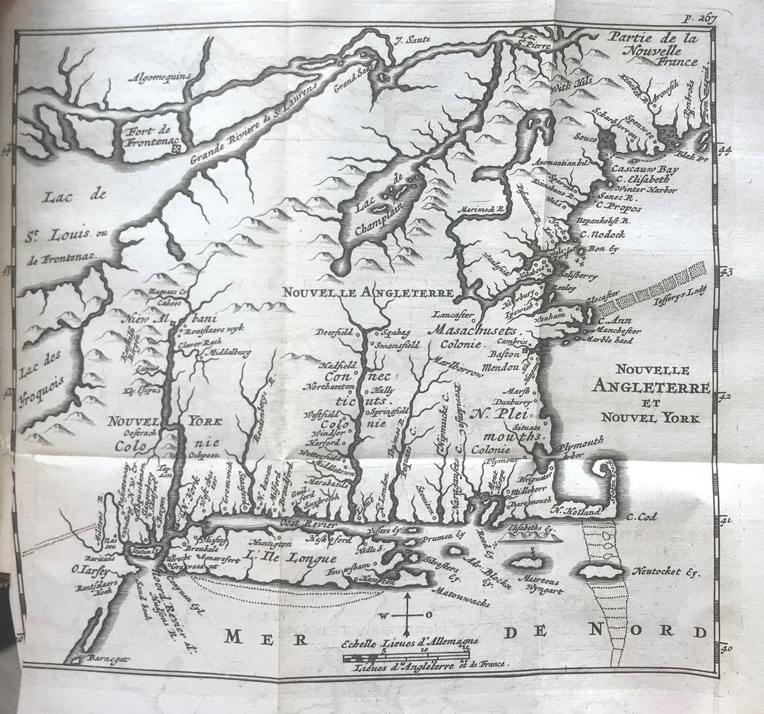
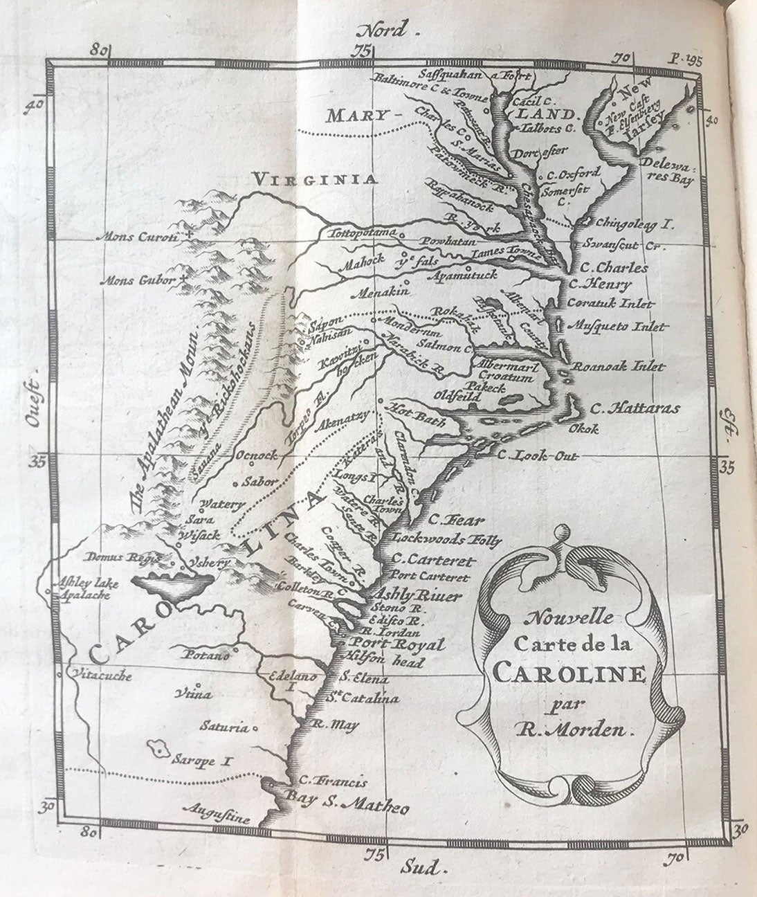
Amsterdam: Chez Abraham Wolfgang prés la Bourse, 1688. 24mo, early calf covers with later calf spine, gilt author, title, etc. at spine, marbled endpapers. [iv], 331, [1] pp., 7 folding maps. CONDITION: Good, front hinge cracked but holding firm, rubbed. First edition in French of Blome’s guide to British North America, first published in English in 1687, written to encourage settlement and to advise prospective settlers "on measures they should take to settle and to provide themselves with a comfortable subsistence…” (Preface). A noted compiler and publisher of geographic works, Blome treats British America in its entirety, including the colonies in the West Indies, with accounts of towns, climates, productions, laws, religions, etc. Included are seven maps: Carte de la Jamaique Nouvellement Reveue; Ile des Barbades (by R. Morden); Nouvelle Carte de la Pensylvanie Maryland, Virginie et Nouvelle Iarsey; Les Barmudes (by R. Morden); Nouvelle Carte de la Caroline (by R. Morden); Nouvelle Angleterre et Nouvel York; and Partie de L’Amerique Septentrionale (by R. Morden). Nouvelle Carte de la Pensylvanie Maryland, Virginie et Nouvelle Iarsey is present in the second state, with Chesapeake spelled “Cheseapeack” not “Chesenpeack.” According to Burden the map “is not derived from any clear source. An unusually slim New Jersey is depicted and the border between Maryland and Pennsylvania is placed too far north, just south of Philadelphia. The Delaware peninsula is leaning eastwards slightly and is broader at its neck than accepted at the time.” Regarding Nouvelle Angleterre et Nouvel York, Burden notes that it “bears no direct resemblance to either the Blome of 1672, or the Morden which appeared in the Blome edition of 1687. The inland waterways and Cape Cod, in particular, are very disparate. New York is shown at the tip of a peninsula rather than being an island, and the Hudson River bears an abrupt bend upriver.” While the example of this map illustrated in Burden does indeed show New York at the tip of a peninsula, on the example in the present volume, as well as others we have seen, a river bisects the peninsula, resulting in the tip appearing as an island, suggesting that this is a corrected state of the map. "Important for its promotion of European emigration to America and for its reprint [from Increase Mather's Illustrious Providences, 1684] of the captivity of Quintin Stockwell."—Vail 252. REFERENCES: Sabin 5970; Howes B546; Vail 252 & 253; European Americana 688/32; Bibliotheca Americana: catalogue of the John Carter Brown Library in Brown University, books printed 1675-1700, p. 186; Burden 638, 639, 640, 641 and 642 for five of the maps.
Item #7393
Price: $2,950.00