
Sign up to receive email notices of recent acquisitions.
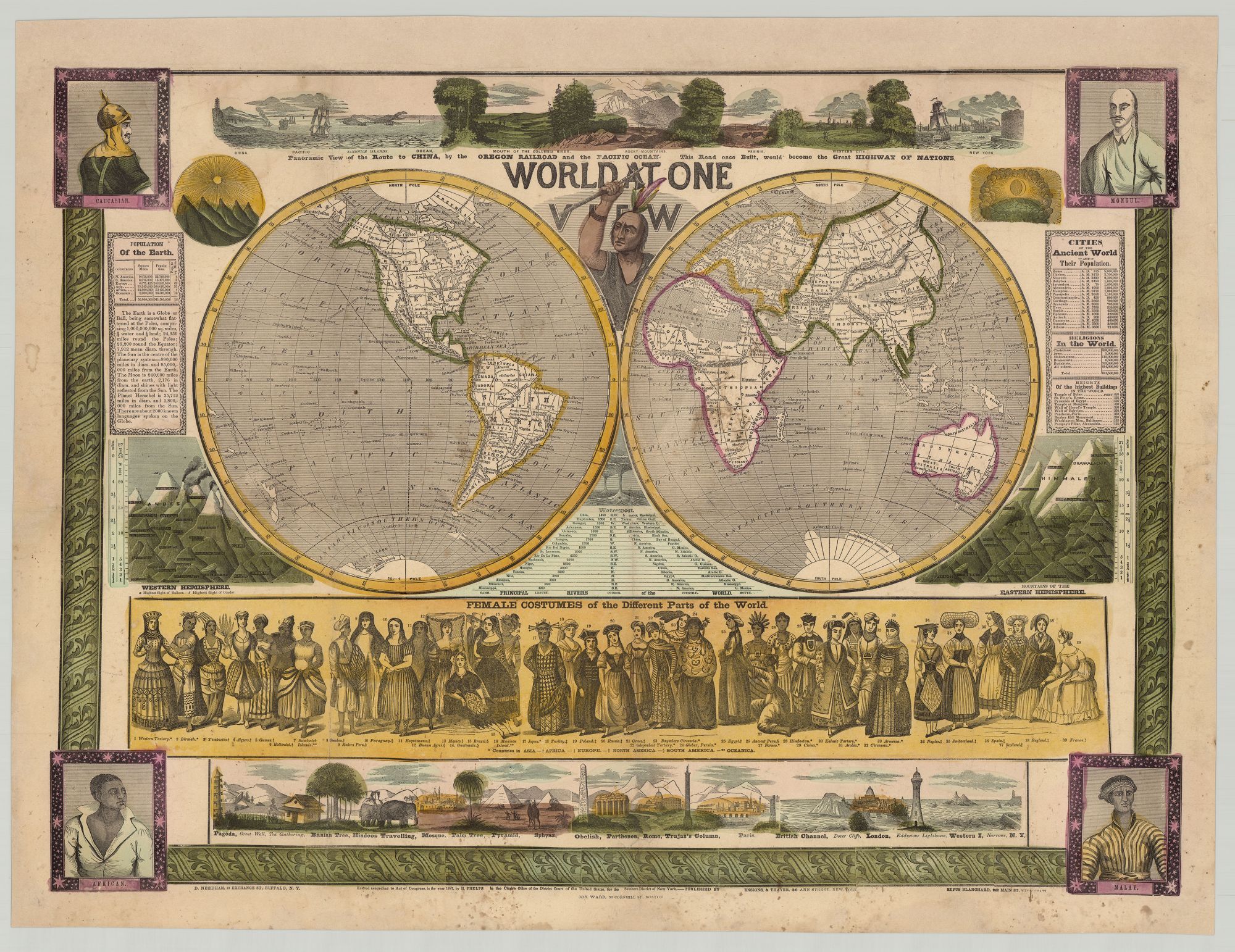
World at One View.
New York: Ensigns & Thayer; Buffalo: D. Needham; Cincinnati: Rufus Blanchard; Boston: Jos. Ward, 1847. Hand-colored wood engraving, 29” x 21”, plus margins, map and illustrations within ornamental border. Expertly reinforced on verso with Japanese tissue. CONDITION: Very good, re-margined at top, moderate foxing and other light stains. A scarce illustrated broadside map presenting a compressed view of the world to 1840s America, emphasizing human geography and the prospect for expanded interconnectedness and trade. Geographically and pictorially informing the U.S. public of the wider world and America’s place in it, this double hemisphere map is surrounded by inset scenes of people from different nations, various architectural landmarks and forms of the world, informational tables, and views of mountains. Portraits in each of the four corners depict men characterized as Caucasian, Mongol, African, and Malay, and peeping out between the two hemispheres is a Native American raising a hatchet (possibly referencing the ongoing conflict with Native Americans). The inset below the map, entitled “Female Costumes of the Different Parts of the World,” pictures thirty-nine women in costume representing a broad spectrum of nations. Perhaps the most telling pictorial element here is an illustration across the top presenting a compressed “panoramic view” of the route from New York Harbor to China via “the Oregon Railroad” (a reference to proposals for a trans-continental railroad) and the Pacific Ocean, infused with the notion of Manifest Destiny. Text below the view notes: “This road once built, would become the great highway of nations.” Other inset images depict mountains of both the Eastern and Western Hemispheres, the latter showing the highest flight of a balloon and a condor. The lower composite view extends from a pagoda and the Great Wall of China on the left to London and New York on the right, and includes representative or iconic views from around the world, including a pyramid, “the British Channel,” Paris, a mosque, London, Hindoos Traveling, and so forth. Several tables cover the heights of mountains and the lengths of the principal rivers of the world; populations of modern and ancient cities; religions of the world; and heights of the tallest buildings in the world. Relief is shown by hachure. In Mapping the Nation, Susan Schulten notes that this broadside map is “designed to show the world in a synoptic fashion that was easily understood, even intuitive,” and uses data to characterize the world’s people and nations. Schulten also writes that “[t]he image suggests the playfulness of contemporary graphics designed for teaching.” Matthew Edney, on the other hand, has argued that the work persuasively presents a “vision of the United States of America as the next great world empire.” Based in New York, Humphrey Phelps produced maps, books, and broadsides from 1841 to 1853. At various times, Phelps co-published with Ensign & Thayer as well as Gaylord Watson. Other works Phelps published include Presidents of the United States (New York, 1846), and a series of folding maps for travelers, which he started producing in 1838. OCLC records just three copies, at the Osher Map Library, AAS and the University of Iowa. REFERENCES: Edney, Matthew. “Mapping Empires, Mapping Bodies: Reflections on the Use and Abuse of Cartography,” Treballs de la Societat Catalana de Geografia, no. 63 (2007), pp. 92-93; Peters, America on Stone, p. 325; Rumsey 5937 (lacking the Boston and Cincinnati imprints); Schulten, Susan. Mapping the Nation: History and Cartography in Nineteenth Century America (University of Chicago Press, 2012), p. 30.
Item #7614
Sold