
Sign up to receive email notices of recent acquisitions.
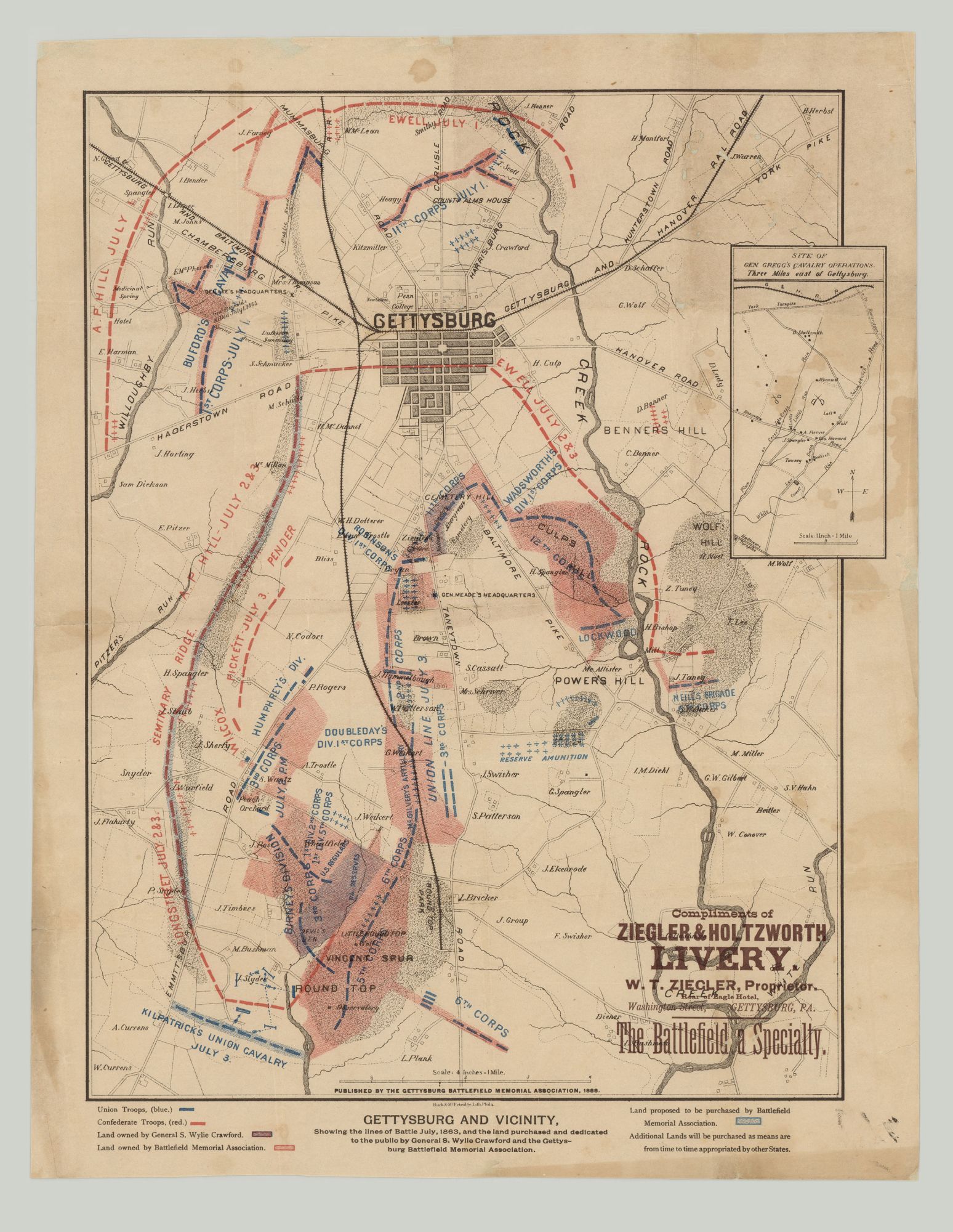
Gettysburg and Vicinity: showing the lines of battle July, 1863, and the land purchased and dedicated to the public by General S. Wylie Crawford and the Gettysburg Battlefield Memorial Association.
Philadelphia: Gettysburg Battlefield Memorial Association; 1888. Burk & McFetridge, Lith. Chromolithograph, 12.75” x 17”, plus margins, printed in red, black and blue. Overprinted advertisement in brown ink in bottom-right corner. CONDITION: Good, old folds, light staining to map and margins, a few tiny losses to the upper-right corner, a few small losses to printed area, light chipping and toning to margins. A scarce 1880s map for Gettysburg Battlefield tourists, showing troop positions and movements during the three-day battle as well as the progress made by the Gettysburg Battlefield Memorial Association to preserve the battlefield—an effort that ultimately led to its establishment as a national park. Simultaneously depicting all three days of the battle (July 1st, 2nd and 3rd), this map shows Union and Confederate troop positions and movements (Union in blue, rebels in red), as well as points of interest on the battlefield such as General Headquarters, where Gen. John F. Reynolds was killed, and so forth. Text indicates which day of the battle the military positions and movements were occupied or took place. Corps and divisions are identified and commanding officers sometimes named. Showing the town of Gettysburg at upper-middle, the map spans from White Run river in the east to Willoughby River in the west, and from Kilpatrick’s Union Calvary in the south to Gen. Richard Ewell’s troops in the north. The inset map in the upper-right shows the site of Gen. Gregg’s Cavalry operations, located three miles east of Gettysburg. Also included are such granular details as drainage, fences, roads, rivers, railroads, vegetation, property lines, houses with names of inhabitants, and so forth. The key indicates land owned by both Gen. S. Wylie Crawford and the Battlefield Memorial Association, and land the Association proposed to purchase. Text at the bottom notes that “additional lands will be purchased as means are from time to time appropriated by other States.” An overprinted advertisement for Ziegler & Holtzworth Livery of Gettysburg appears in the lower right corner, from which visitors apparently rented carriages to tour the battlefield. Published by the Gettysburg Battlefield Memorial Association, the map was likely distributed through Ziegler & Holtzworth as well as other entities and apparently was intended to build support for the preservation cause. Chartered by the Commonwealth of Pennsylvania in 1864, the Gettysburg Battlefield Memorial Association (GBMA) was dedicated to the battlefield’s historic preservation. The organization was formed after lawyer David McConaughy recommended in 1863 a preservation association to sell membership stock for battlefield fundraising. McConaughy transferred his land acquired in 1863 to the GBMA. The Association operated a wooden observation tower on East Cemetery Hill from 1878 to 1895. In 1880, GBMA officers were Grand Army of the Republic members from various states, and by 1882 its funds were nearly exhausted. By 1895 the Association came to an end and a new era of managing Gettysburg’s landscape was ushered in. A bill introduced in Congress in 1894 was signed into law in 1895, which saw the GBMA cede control of 522 acres, seventeen miles of avenues, and 320 monuments to the U.S. War Department. The federal Gettysburg Park Commission was established by the War Department in 1893, the year the federal government began acquiring GBMA land. The Gettysburg National Military Park was established in 1895 and today is managed by the National Park Service. Based in Philadelphia, lithographers William M. Burk & John R. McFetridge operated from 1877 to 1900. The partnership produced trade cards, advertising posters, and book illustrations. Burk & McFetridge began as a successor to the Inquirer Printing House in 1877, where Burk had been a manager from 1862 to 1877. In 1887, they printed the plates for the U.S. Quartermaster General’s Flags of the United States Carried During the War of the Rebellion. OCLC records only five copies, at the University of Alabama, Yale, the Clements Library, Wisconsin Historical Society, and the University of Wisconsin, Milwaukee. REFERENCES: Stevenson, Civil War Maps (2nd ed) #334 for an 1886 issue; Last, Jay. The Color Explosion: Nineteenth-Century American Lithography (Santa Ana, CA, 2005), p. 172.
Item #8084
Sold