
Sign up to receive email notices of recent acquisitions.
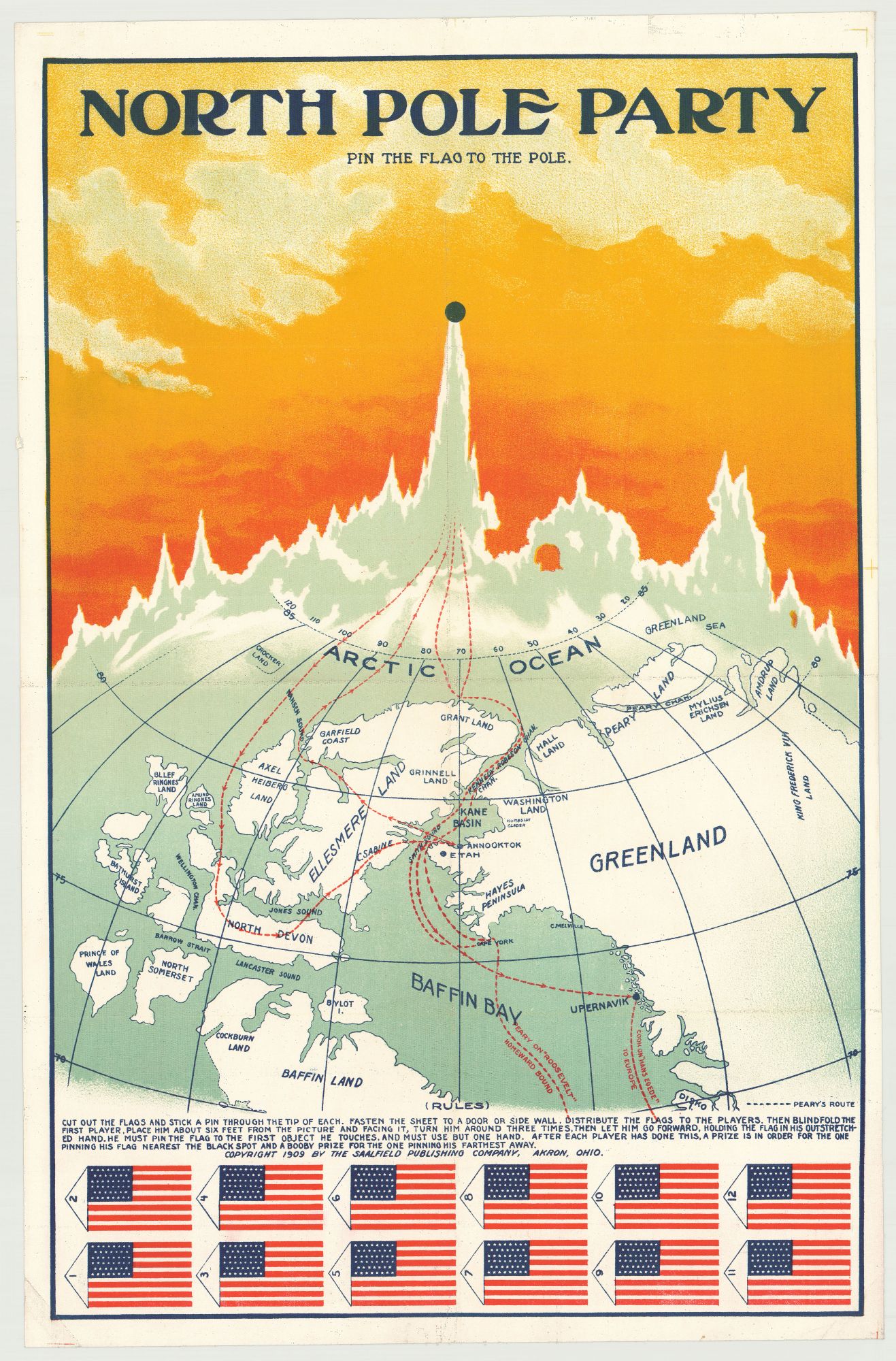
North Pole Party. Pin the Flag to the Pole.
Akron, Ohio: Saalfield Publishing Company, 1909. Chromolithograph on linen, 26.5” x 17”, plus margins, map with text and two rows of flags across bottom. A scarce and visually arresting ‘pin-the-flag’ map game, issued in the year that Robert Peary and Frederick Cook both claimed to be the first to reach the North Pole. This map depicts the theater of Arctic exploration, including Greenland, Baffin Land, Baffin Bay, Ellesmere Land, the Arctic Ocean and other Arctic land-masses and bodies of water. Red dotted lines—labeled “Cook on ‘Hans Egede’” and “Peary on ‘Roosevelt’’”—trace the respective routes of Peary and Cook in 1908 and 1909. A series of frosty peaks extends across the top edge of the globe, the highest of which, surmounted by a black dot, represents the North Pole. Featured below the map are twelve American flags which were meant to be cut out, as noted in the rules: “Cut out the flags and stick a pin through the tip of each. Fasten the sheet to a door or side wall. Distribute the flags to the players. Then blindfold the first player, place him about six feet from the picture and facing it, turn him around three times, then let him go forward, holding the flag in his outstretched hand. He must pin the flag to the first object he touches, and must use but one hand. After each player has done this, a prize is in order for the one pinning his flag nearest the black spot and a booby prize for the one pinning his farthest away.” At the turn of the century the quest for the Pole became an international race, with England, Norway, and the U.S. all competing for the honor. On the heels of three failed attempts (1893; 1898–1902; 1905–06), U.S. Navy Commander Robert Peary undertook his final expedition from 1908 to 1909. On 5 Sept. 1909 Peary emerged from the Arctic to announce to the world that he had reached the Pole on 6 April. Around the same time, however, Peary’s former colleague, U.S. explorer Frederick Cook claimed that he had reached the Pole a full year earlier, in April of 1908. Cook’s claim was soon debunked (he lacked sufficient proof), while Peary’s claim also ran into trouble: his evidence was thin, and he was unwilling to disclose his logbooks and diaries which may have substantiated his claim. A 1911 Act of Congress recognized Peary’s claim but the scientific community remained divided over its veracity. The dispute continues today. Saalfield Publishing Company of Akron, Ohio produced children’s books, toys, and games. Founded by Arthur J. Saalfield, the company operated from 1900 to 1977, and for a period was one of the world’s largest publishers of children’s materials. No records in WorldCat. A scarce and very appealing map game reflecting popular interest in the race for the North Pole. REFERENCES: Robert Peary American Explorer at britannica.com; Robert E. Peary describes planting the American flag at the North Pole, 1909 at eyewitnesstohistory.com CONDITION: Very good, slight losses along flattened old vertical and horizontal folds, a few old creases, small piece of margin coming loose at left.
Item #5657
Sold