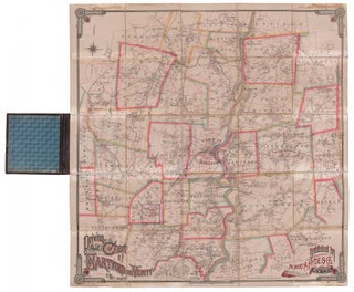
Driving Road Chart of...
A large and handsome carriage-road map representing the extensive network of roads in the city of Hartford, Connecticut and the surrounding area, published during the peak of the carriage era. This highly detailed map shows cities, towns, roads, mills, factories, dwellings and their owner’s names, railroads, rivers, lakes, etc. It.....
![Item #3547 [Penobscot Bay to Blue Hill Bay, Maine]. J. F. W. Des Barres](https://jamesarsenault.cdn.bibliopolis.com/pictures/3547_1.jpg?width=320&height=427&fit=bounds&auto=webp&v=1669738995)