
Sign up to receive email notices of recent acquisitions.
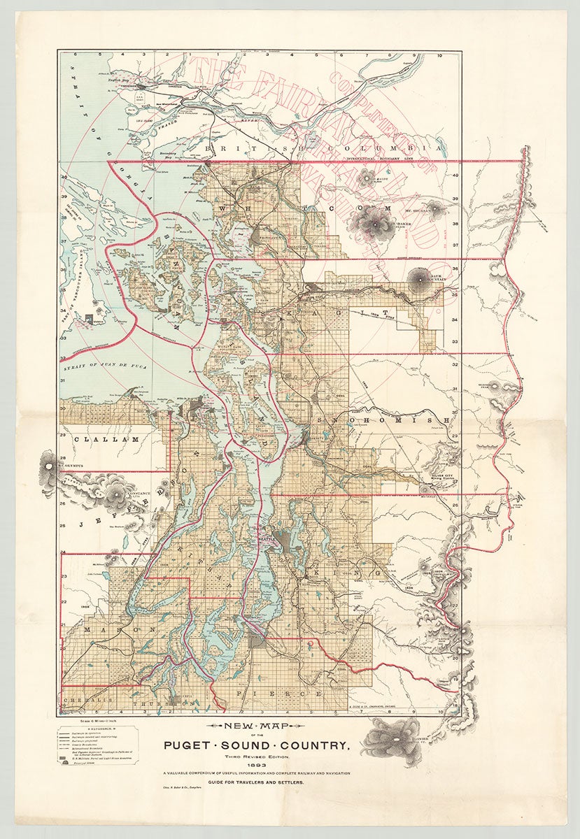
New Map of the Puget Sound Country. Third Revised Edition. A Valuable Compendium of Useful Information and Complete Railway and Navigation.
Fairhaven, Washington: Chas. H. Baker & Co., Compilers; Chicago: Z. Zeese & Co., engravers, 1893. Map, 30.75” x 20”, plus margins. A large promotional map of the Puget Sound area in Washington state published to attract travelers and settlers to the booming town of Fairhaven, which became a terminus of the Northern Pacific Railroad. Issued by Fairhaven Land Company, the map extends from Stevens Pass in the east to Mt. Olympus in the west, and from Vancouver in the north as far south as Mt. Rainier. Cities such as Seattle, Tacoma, Bellingham, and Vancouver are shaded in gray, while surveyed lands are printed in tan. Numerous mountains are shown as well as iron and coal deposits, prairies, falls, ports, mines, harbors, hills, and numerous bodies of water. County borders are shown in red and a series of red concentric circles indicate distances from Fairhaven. In the upper right corner the Fairhaven Land Company’s name is overprinted in red. A key at the lower-left identifies cities; county and international boundaries, railways in operation, under construction, and planned; soundings in fathoms in the harbors; and U.S. military, naval, and lighthouse reserves. The railroads shown include Everett & Monte Cristo R.R., Northern Pacific R.R., Puget Sound Shore R.R., and more. Development of the town of Fairhaven on Bellingham Bay was spearheaded by the Fairhaven Land Co., which was instrumental in not only building a railroad connecting Fairhaven with the rest of the U.S. but also in creating an international port in Fairhaven. In 1888, the town began growing rapidly—seeing a spike in its population from about 150 in 1889 to 8,000 by 1890. Fairhaven’s development was due largely to promoters who anticipated that it would become the western terminus of the Great Northern Railroad, and advertised its land of rich natural resources, mild climate, and possibilities for wealth and prosperity. In 1903 Fairhaven became part of the city of Bellingham. REFERENCES: Radke, August C. Pacific American Fisheries, Inc. (Jefferson North Carolina: McFarland & Co., 2002), p. 14; 1889 Fairhaven at fairhavenhistory.com CONDITION: Very good, light toning along the folds, more generalized toning in lower half, small neatly repaired losses at edges, occasional light soiling to margins.
Item #5658
Sold