
Sign up to receive email notices of recent acquisitions.
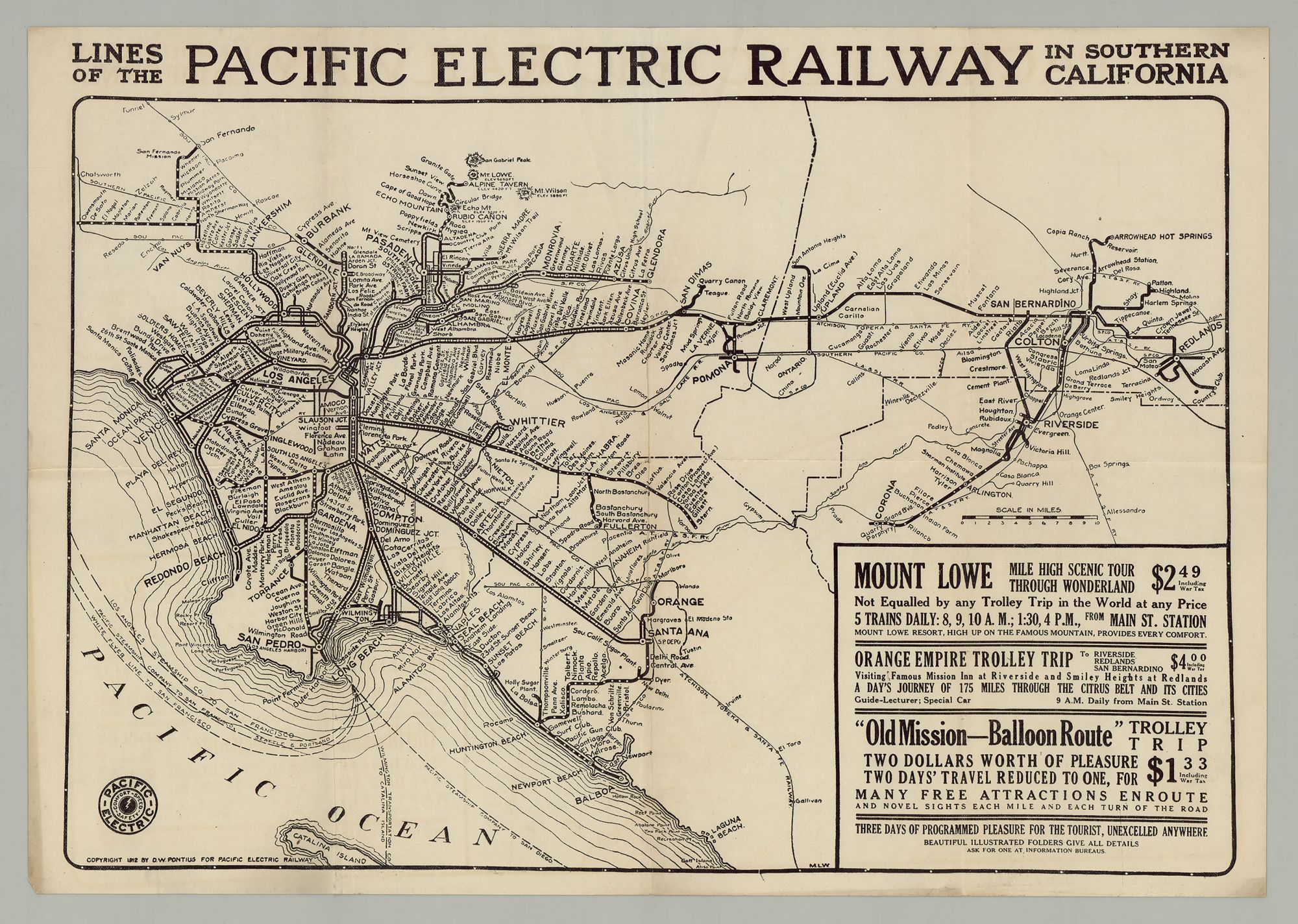
Lines of the Pacific Electric Railway in Southern California.
[California]: for Pacific Electric Railway, 1912. 12” x 17” including margins. A scarce map of the Pacific Electric Railway, published a year after Henry E. Huntington lost possession of the company, as it began to rapidly expand, becoming—only a decade later—the world’s largest electric railway system. Boasting of "Comfort–Speed–Safety," the Pacific Electric Railway (fondly called the Red Cars) was a privately-owned mass transit system in Southern California, founded at the turn of the century and operating well into the second half of the 20th century. Ten years prior to the publication of this map, in November 1901, the eminent book collector and railroad tycoon Henry E. Huntington, along with several investors and the banker I. W. Hellman, would incorporate the Temple Street Cable Railway and the Pasadena and Mt. Lowe Railway into the Pacific Electric Railway Company, which would run until 1961 (Dickinson). At its height, the interurban system—consisting of electrically powered streetcars, interurban cars, and buses—covered some 1,100 miles of electrified rail; featured over 2,700 daily trains; and served thousands of commuters, travelers, and tourists alike. This map of the Pacific Electric Railway (the PE) was made a year after Huntington lost control of his new railroad to the Southern Pacific Transportation Company, which took over the PE in 1911 and would manage it until the end. Under this new ownership the railway grew significantly, incorporating other small railroads in the Los Angeles area. Called the "Great Merger," the PE became the largest electric railway system in the world by the 1920s. The map depicts the railway’s lines from San Fernando and the Gabriel Mountains in the north to Newport Beach and Balboa in the south, and from Santa Monica, Redondo Beach and San Pedro in the west to Redlands in the east. With trains originating in Los Angeles (indicated by a star at the nexus of multiple rails), the lines extend to all these locations. Virtually every stop is identified along each line and spur. To the South and South-East, the map shows connecting steamship lines, for San Diego, San Francisco, Seattle, and Portland. Also shown is the Wilmington Transportation Co. line from Long Beach to nearby Catalina Island. In the lower right corner, there are three advertisements offering "three days of programmed pleasure for the tourist, unexcelled anywhere”: a trip to the Mount Lowe Resort "high up on the famous mountain" (boasting an elevation of 5,650 ft.), providing "every comfort" and complete with a "mile high scenic tour through Wonderland"; a second trip, dubbed the Orange Empire Trolley Trip (the priciest of the three), which went to Redlands, San Bernardino, and Riverside (and its famous Mission Inn)—a 175 mile trip in total "through the Citrus Belt and its Cities," complete with a guide-lecturer and a special car; and the cheapest of the three, the "Old Mission—Balloon Route" trolley trip, offering "novel sights each mile." While the PE did service freight traffic, its primary business was passenger service, which waned following World War II. After cutting back its operations the PE shut down its interurban services in 1961 and Southern Pacific picked up what remained of its freight operations. Scarce. OCLC records four copies, three at UC Berkeley and one at the California Historical Society. An informative map of the greater Los Angeles mass transit system early in the twentieth century, complete with advertisements for three trolley trips. CONDITION: Good, old fold marks. REFERENCES: Rumsey #3581, for a revised edition of 1927; The Pacific Electric Railway: Comfort, Speed, Safety at www.american-rails.com.
Item #6376
Sold