
Sign up to receive email notices of recent acquisitions.
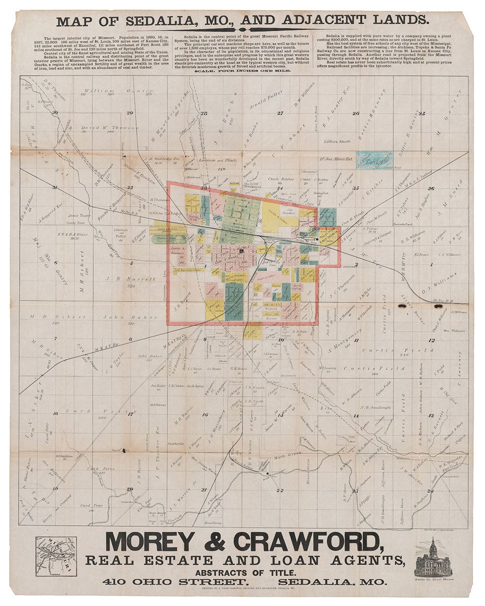
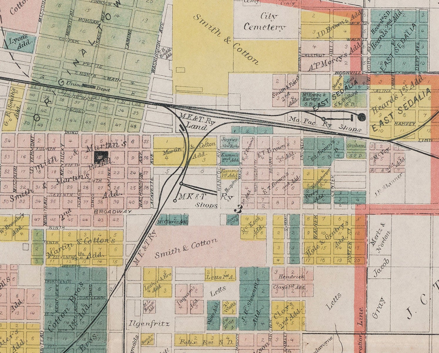
Map of Sedalia, Mo., and Adjacent Lands.
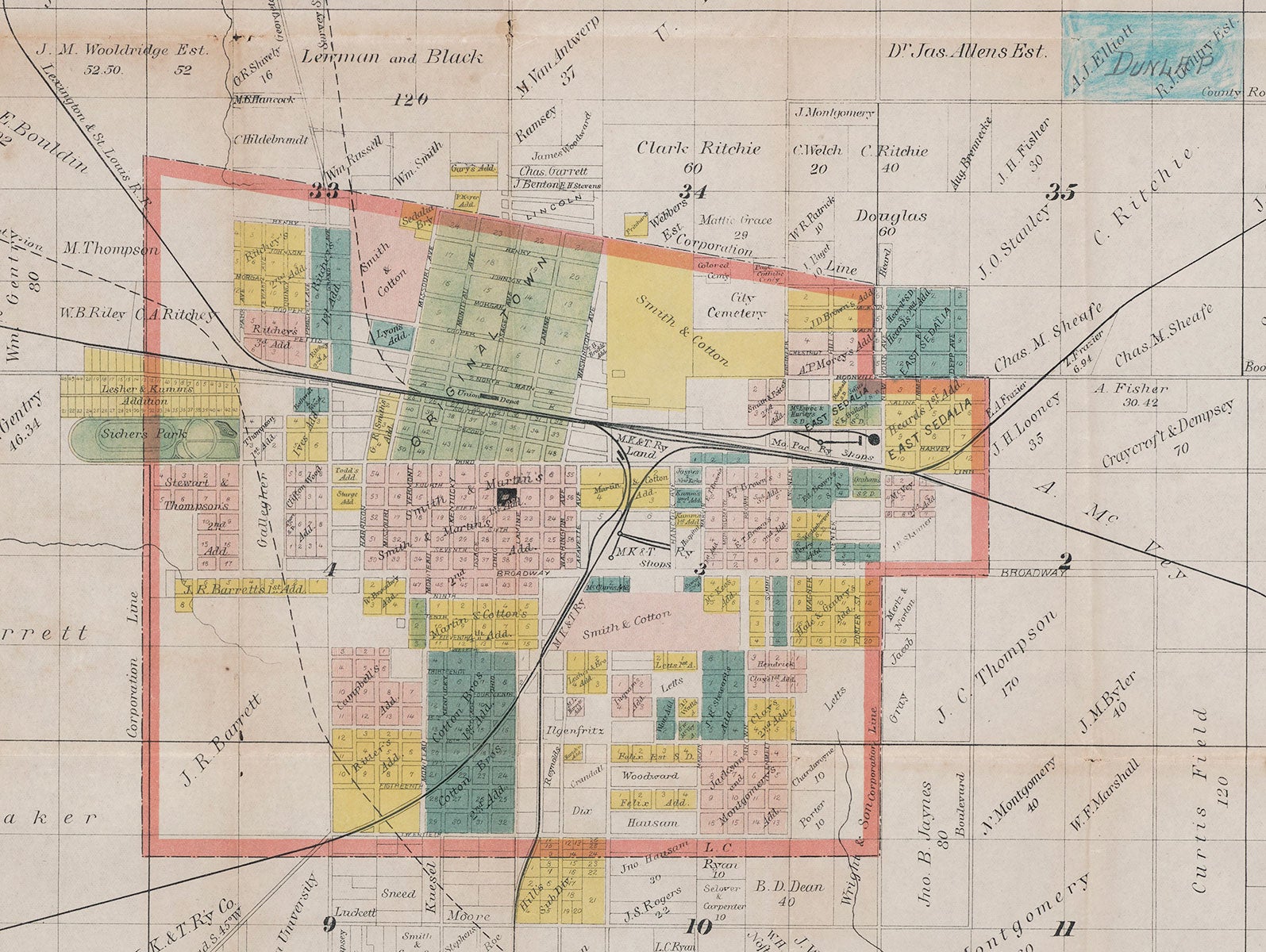
Sedalia, Mo.: Morey & Crawford Real Estate and Loan Agents; Printed by J. West Goodwin, Printer and Engraver, [1887?]. Map printed partly in color, 30.5” x 24”. An unrecorded real estate promotion map for the town of Sedalia, Missouri and vicinity, located at the junction of the Missouri Pacific R.R. and the Missouri, Kansas, and Texas Railway, and situated roughly half way between St. Louis and Kansas City. This attractive map depicts Sedalia highlighted in several colors, which correspond to the original town, various additions, and a park. Numerous plats—both inside and outside the town—are identified by landowner. The prospective line of the Atchison, Topeka & Santa Fe Railway (labeled M.K.&T Ry)—“now in process of construction”—is shown cutting diagonally across the region from the northwest corner to the southeast, while the Missouri Pacific Railway runs horizontally through the town. The city cemetery—located in the town’s northeast corner—has within it a separate “Colored Cemetery.” The promotional text across the top reads in part:
The largest interior city of Missouri. Population in 1860, 18; in 1887, 22,000. 188 miles west of St. Louis, 100 miles east of Kansas City … Central city of the finest agricultural and mining State of the Union. Sedalia is a central railway and distributing point of the great interior prairie of Missouri, lying between the Missouri River and the Ozarks, a region of unexampled fertility and of great wealth in the ores of iron, lead and zinc, and with an abundance of coal and timber … this great western country has been so wonderfully developed in the recent past, Sedalia stands pre-eminently at the head as the typical western city, but without the feverish mushroom growth of forced and artificial boom…real estate has never been exhorbitantly high, and at present prices offers magnificent profits to the investor.
Also noted are the supply of pure water in the town; free schools; the employment of some 1,500 in the “principal car and machine shops”; the projected increase of the railroad facilities and roads, and so on. Situated ninety miles east of Kansas City and 190 miles west of St. Louis, Sedalia was founded in 1860 as a railroad town and serves as the seat of Pettis County in west-central Missouri. Town founder Gen. George R. Smith established the city in an effort to attract the Pacific R.R. to the fledgling community after its neighboring town Georgetown failed to attract railroad investment. In 1860, the Missouri legislature chartered the Tebo & Neosho R.R. Co. to build a line between the location that later become Sedalia and Neosho, Missouri. In 1861, Sedalia became the terminus of the Pacific R.R. and saw its first train passengers that year. While the Civil War stalled plans for the Tebo & Neosho, when the war ended the legislature changed the charter to set the terminus of the line at Fort Scott, Kansas instead of Neosho. 1870 saw the first passenger train depart from Sedalia via the Missouri, Kansas & Texas R.R. (MK&T). Sedalia’s transformation from a frontier community to a town occurred in the 1870s due to the growth of the railroads, which continued to fuel growth in the ‘80s. The Depression hit Sedalia hard—Life Magazine identified Sedalia as the city hit second hardest in America. Railroad strikes in the early ‘20s had also weakened Sedalia’s economy. The decline of passenger rail service coupled with the rise of the automotive industry impacted the MK&T, and in 1958 the last MK&T passenger train passed through Sedalia. Rare. Not in OCLC, Antique Map Price Record, Rumsey or Phillips. REFERENCES: About Sedalia at ci.sedalia.mo.us; A Brief History of Downtown Sedalia at downtownsedalia.com CONDITION: Good, old folds, two small holes along one fold not affecting printing, some toning along folds.
Item #3312
Price: $950.00