
Sign up to receive email notices of recent acquisitions.
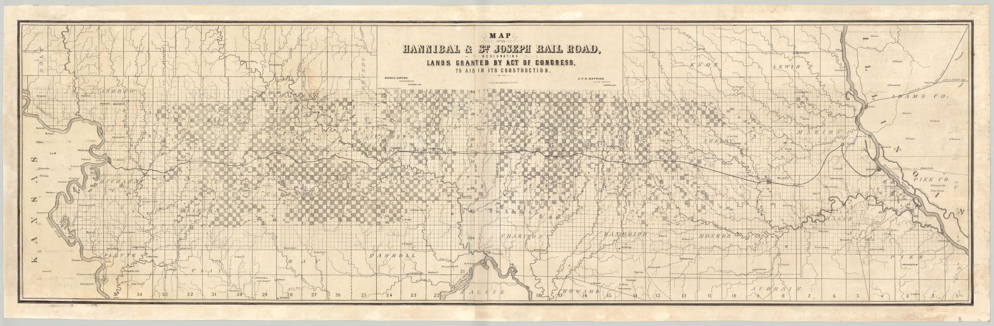
Map of the Hannibal & St. Joseph Rail Road, Designating Lands granted by Act of Congress, to Aid in its Construction.
Boston: From Office of George C. Rand & Avery, 3 Cornhill, [ca. 1859]. Meisel Bros., Lith. Lithograph on two joined sheets, 22.5” x 71” plus margins, recently backed with mulberry paper. CONDITION: Good, repaired fissures and minor breaks, mainly in the margins; very presentable. A rare, early, and large map of the first railroad across Missouri, intended to promote the lands granted by the U.S. government to fund its construction. Likely published while the railroad was under construction, this map depicts the Hannibal & St. Joseph in its entirety, extending across the northern part of the state, with lands for sale both north and south of the railroad shaded in gray. A large grid is superimposed on the map, with further subdivisions within the region of the land grant. The towns located along the line are Palmyra, Monroe, Hunnewell, Chilicothe, Utica, and Stewartsville. The Hannibal & St. Joseph was first planned at an 1846 meeting held in the Hannibal, Missouri office of Mark Twain’s father, John Marshall Clemens, a local judge and merchant. Construction began in both cities in 1851 and ended in February of 1859, when the two lines were joined in Chillicothe. Spanning the entire state of Missouri and connecting the Mississippi and Missouri Rivers, the Hannibal & St. Joseph proved a railroad of great importance for the development of the state, as well as westward expansion in general. At the time of the completion of the railroad, St. Joseph was the westernmost city accessible by rail and remained such until 1867, when the Cedar Rapids and Missouri River Railroad reached Council Bluffs. Previously serving as a principle point of departure for the Oregon Trail, St. Joseph served a similar purpose during the Pike’s Peak Gold Rush, with many prospectors arriving there via the H&SJ once it was completed. The railroad published an eight-page guidebook entitled Hannibal & St. Joseph Railroad Guide to Western Iowa, Kansas, Nebraska, and the Gold Mines of the Rocky Mountains, Oregon, Utah, and California (1860), as well as other promotional items. During the Civil War, the railroad transported Union troops and supplies, and played an important role in postal communications, serving as a primary link to the Pony Express and the overland stage. It also hosted a “post office on wheels” for sorting the mail prior to its arrival in St. Joseph. Following the War, a spur to Kansas City was built, along with the Hannibal Bridge over the Missouri, connected the Texas cattle trade with Chicago. OCLC records just one copy of this map, at Yale, described as “printed on linen.” The copy offered here is printed on paper, but was mounted on its original linen when we acquired it. We have since had it removed and backed with mulberry paper. OCLC also records one copy of a map entitled Map of the Hannibal & St. Joseph Rail Road showing by shading its 600,000 acres of land for sale, of essentially the same dimensions and also printed by Meisel, which is very likely the same map offered here with a variant subtitle. A rare map of this important railroad linking the eastern U.S. with the west. REFERENCES: “Missouri’s Hannibal & St. Joseph Railroad Opens” at Civil War on the Western Border, The Kansas City Public Library online.
Item #4420
Price: $4,750.00
Add to Wish List