
Sign up to receive email notices of recent acquisitions.
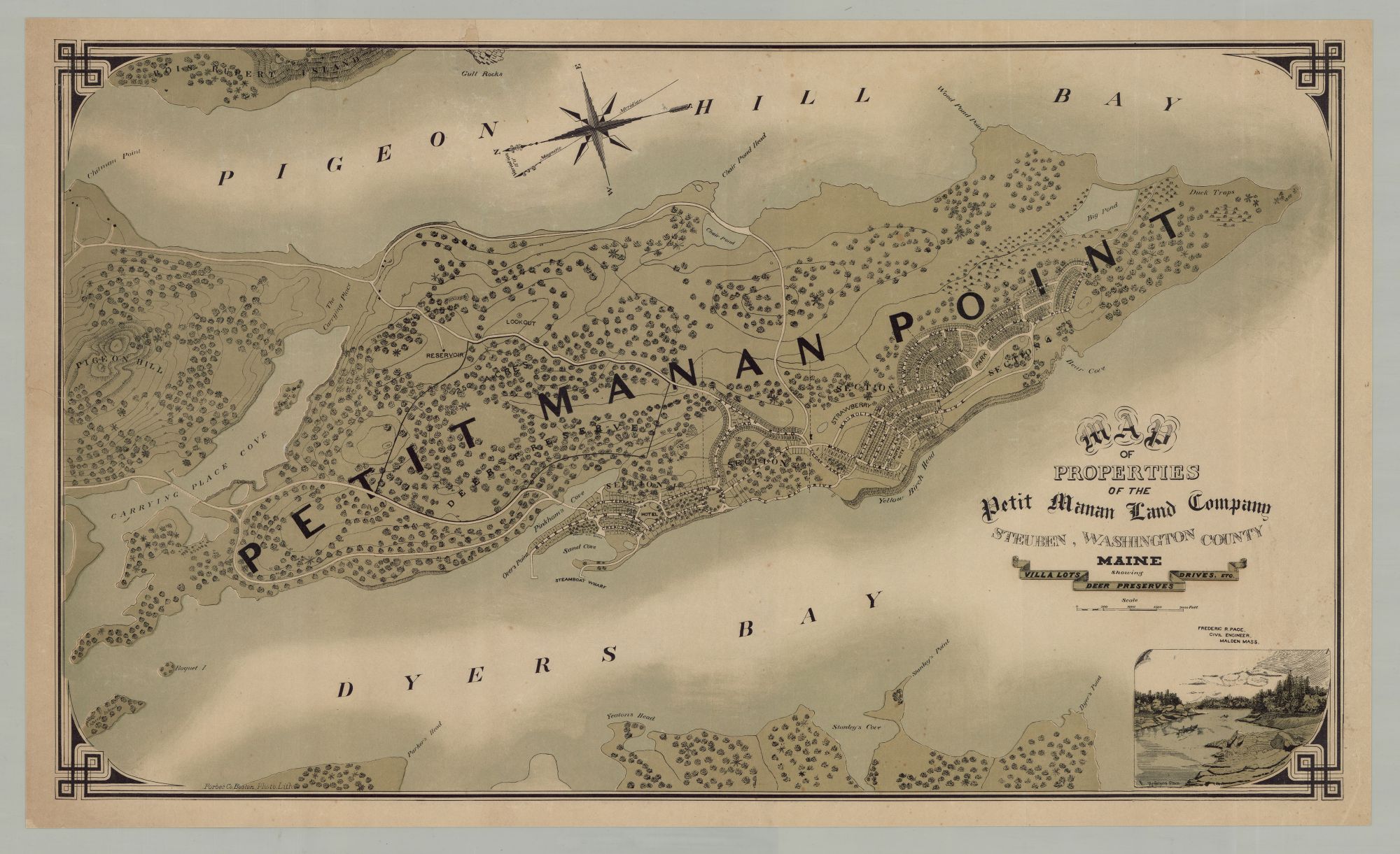
Map of Properties of the Petit Manan Land Company Steuben, Washington County Maine Showing Villa Lots, Deer Preserves, Drives, Etc.
[Auburn, Maine and Boston: Petit Manan Land Co., ca. 1885; Forbes Co. Photo. Lith.] Tinted lithograph, 19.25” x 33.5” plus margins, with decorative border. CONDITION: Good, a few small stains, a few small repairs at upper margin and border and in the lower-right margin. One of the most impressive Maine real estate promotion maps published in the nineteenth century, showing the proposed development of Petit Manan, just to the east of Bar Harbor, in Washington County. This large and captivating plan shows Petit Manan Point in its entirety, featuring a plat on its western shore delineating numerous “villa lots” for sale, which are divided into four named sections as well as a hotel site. The map extends from the vicinity of Pigeon Hill in the north to the tip of Petit Manan Point in the south, and from Rois Rupert Island in the east to Stanley’s Cove in the west. Among the various details included are roads, coves, bays, points, forests, parks, bodies of water, beaches, a lookout, a reservoir, islands, a steamboat wharf, and a 250 acre deer preserve. An inset vignette in the lower-right corner shows “The Carrying Place” (which is located in the middle-left portion of the map), where two canoes ply the waters of Carrying Place Cove. Relief is shown by hachure and contour lines. Immediately following the Civil War, a number of factors aligned to make Maine an appealing summer destination. America’s developing economy afforded the upper classes leisure time, and the modernization of railway and steamship transportation enabled fast, affordable access to emerging coastal resorts like Bar Harbor and Old Orchard Beach. Resort and summer colony land development in Maine in the later nineteenth and early twentieth centuries also coincided with problems of crowding, disease, and sanitation in cities, which drove city dwellers in the northeast to search for a simpler, more healthy environment during the hot summer months. Investors purchased land along Maine’s coastline, which they subdivided and promoted in brochures, maps and views. A recent census of such maps compiled by scholars Earle Shettleworth and Willie Granston records some thirty-two known examples, including maps for developments in such locales as Diamond Island in Casco Bay, Cape Arundel, Old Orchard Beach, Sorrento, Winter Harbor and elsewhere. By 1881, all of Petit Manan Point (2,178 acres) in Steuben, Maine was owned by Boston businessman Sylvester K. Abbott (1831–1890). Seeking to imitate the success of nearby Bar Harbor, Abbott and a group of investors steered the area away from sheep farming and towards commercial development. In 1889, Abbott transferred his land to the Petit Manan Land Co., which was headquartered in Auburn. After Abbott died in 1890, the Company survived him and in 1896 devised an ambitious plan for the development of Petit Manan Point and invested money in the construction of roads and public buildings. However, by 1910 only a few private cottages and a church were built. The big money and thriving development eluded company after company for sixty years, which sought to transform the quiet farming area into a bustling community for wealthy tourists. The area continued with only a few changes, and in 1975, a large portion of the land was transferred by Mr. and Mrs. William Mague to become the Petit Manan National Wildlife Refuge. Today Petit Manan Point is part of the Maine Coastal Island National Wildlife Refuge. Born in England, William H. Forbes (1836–1915) immigrated to the U.S. at a young age and in 1863 established a lithographic firm in Boston. Forbes produced labels, music covers and theatrical posters, trade cards, maps, bird’s eye views, and more. In 1884, the firm moved into a large new production plant in Chelsea, Mass. Forbes died in 1915, and in 1960 the firm was absorbed by the Diamond National Corporation. OCLC records just three examples, at Yale, the Library of Congress, and AAS. A scarce and very impressive Maine summer colony promotional map. REFERENCES: Billings, Sean. Petit Manan Land Company Near Bar Harbor, Maine (South Carolina: Arcadia Publishing, 2020), pp. 1–40; Last, Jay. The Color Explosion: Nineteenth-Century American Lithography (Santa Ana, CA, 2005), p. 78; Shettleworth Jr., Earl G. The Summer Cottages of Isleboro 1890–1930 (Isleboro, ME: Isleboro Historical Society, 1989), pp. 10–11.
Item #6500
Price: $2,250.00
Add to Wish List