
Sign up to receive email notices of recent acquisitions.
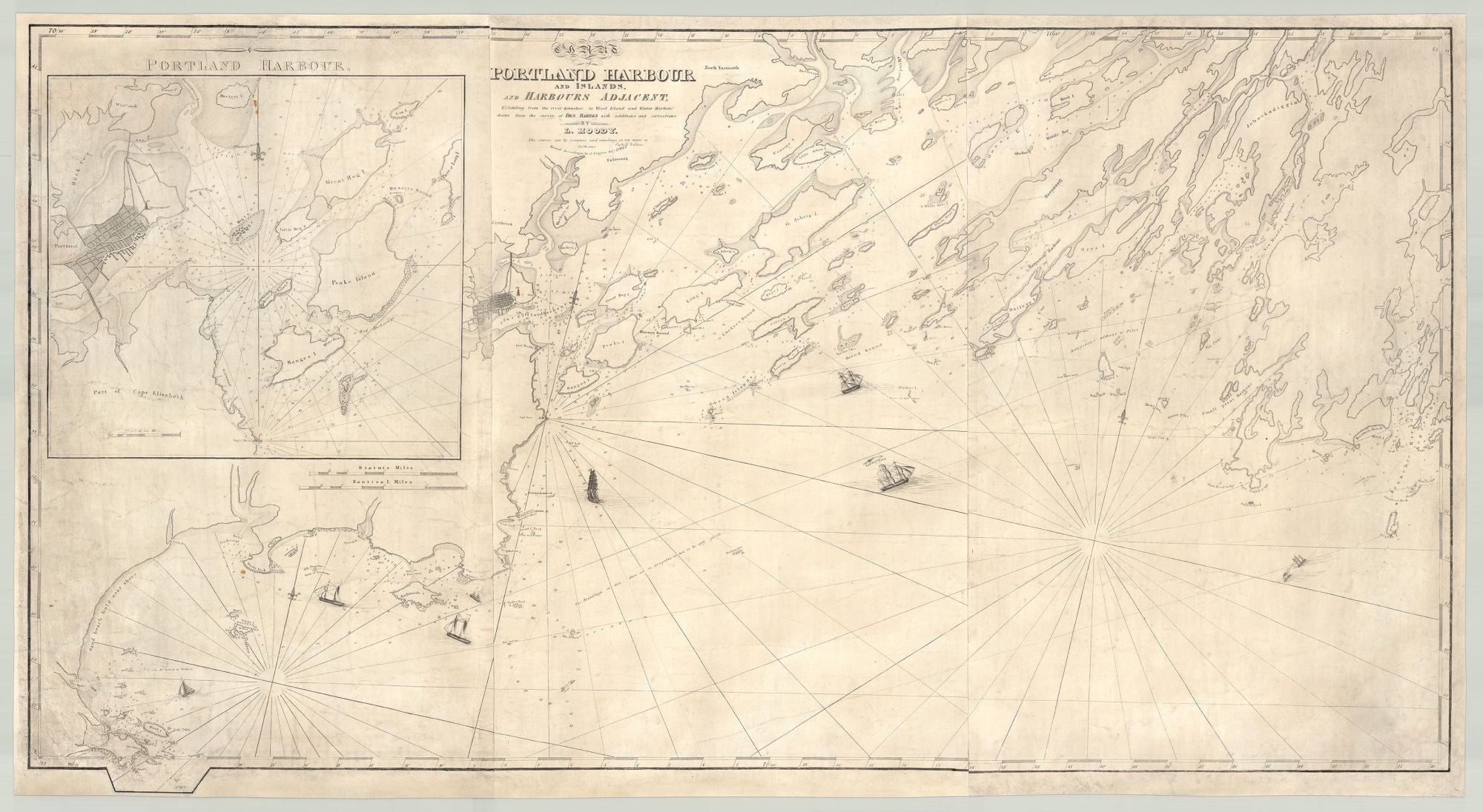
Chart of Portland Harbour and Islands, and Harbours Adjacent, Extending from the river Kennebeck to Wood Island and Winter Harbour, drawn from the survey of Des Barres with additions and corrections.
Portland, 1825. Engraved by D. G. Johnson. Engraving with a touch of hand-coloring, 25.5” x 49”, printed on two joined sheets. CONDITION: Good, some soiling consistent with use, expert reinstatement of loss to border in upper left corner, additional occasional reinstatement of small losses to margins. The first chart of Casco Bay published in the United States and the first attempt to improve upon the Samuel Holland / J. F. W. Des Barres chart of the same region published in London nearly fifty years before in The Atlantic Neptune. The “additions and corrections” were quite extensive and Moody’s efforts resulted in an essentially new chart of the area (notwithstanding the title reference to Des Barres), as well as one more readily available to local mariners. This is the first state of chart, distinguished by the presence of a single light tower only at Cape Elizabeth. Subsequent states of the map show two lights identified as “Fixt Lights,” which survive today and are simply known as “Two Lights.” Lemuel Moody (1767–1846) was a ship’s captain, ship owner, scion of a prominent Portland family, and a key figure in the maritime and merchant life of the city. His father, Enoch, settled in Portland (then known as Falmouth) in 1738, working as a housewright and merchant, and serving in various offices, including that of selectman. Lemuel’s brother William participated in the ill-fated Penobscot Expedition during the Revolutionary War. In 1779, at the tender age of thirteen, Lemuel himself enlisted in the US Navy, serving as a water boy with Captain Joseph Pride’s company. In 1799, during the Quasi War, Captain Moody and his crew aboard the schooner Betsey were captured by the French privateer Africa and imprisoned for several weeks. Subsequently, Moody withdrew from the seafaring life and devoted himself to the construction and operation of the Portland Observatory, an important signal tower erected on Munjoy Hill mainly for the purpose of notifying ship owners when their vessels were approaching. Moody was a founding member of the Portland Marine Society (1796) and the Portland Monument Ground (1807, organized to build the Observatory), and served as commissioner of shipwrecks, strays, and lost goods. He taught the art of navigation and use of charts in his house near the Observatory, and compiled a set of sailing directions for Casco Bay, which he considered publishing, but ultimately did not, perhaps concluding that his chart, used in conjunction with Blunt’s sailing directions, was sufficient. Moody occupied the Observatory from the time it was erected in 1807 until his dying day in 1846, not only operating his signal service, but also making careful nautical and weather observations, which he faithfully recorded, and studying the particulars of Casco Bay as no one before him. Strewn with rocks and ledges, the Bay was extremely treacherous for mariners and the need for an improved chart was readily apparent. In response to the urgings of local ship captains and merchants, Moody compiled a new chart of the region, at first acting in partnership with Captain Seward Porter (who would publish his own Chart of the Coast of Maine, in 1837) and George Deering, both of whom withdrew from the project before publication. Based on Des Barres, as well as Moody’s own observations and surveys, the chart extends from the Saco River to the Kennebec River. It includes a separate inset chart of Portland Harbor, showing the considerable growth of Portland since Des Barres’ time, with its proliferation of streets and docks, as well as the all-important Observatory (picked out in red, both on the inset chart as well as the main chart), prominently perched above the city. The inclusion of Saco Bay and the inset chart represent an expansion of the area treated by the Des Barres chart. Saco Bay appears on a different sheet in the Atlantic Neptune, and the inclusion of it here was likely viewed as a significant improvement, for those who had access to the Des Barres chart at all (or a manuscript copy thereof). More important from a navigational standpoint, Moody’s chart includes soundings, unlike the Des Barres chart, as well as many previously uncharted hazards, such as Hue & Cry, the aptly named ledges off Cape Elizabeth. While the various vessels on the chart heighten its visual appeal, they also serve the practical purpose of illustrating sailing directions, with dotted lines leading from the ships to anchorages near Cape Elizabeth, in Portland Harbor, and in New Meadows Harbor. Of particular interest is a steamboat near Seguin Island, shown towing a sailing vessel away from the mouth of the Kennebec, a dotted line down the Kennebec trailing behind. This vessel is undoubtedly meant to represent the steamboat Patent, purchased by none other than Seward Porter for the Kennebec Steam Navigation Company in 1823, the only steamboat active in the lower Kennebec at the time, and the first to provide regular service between the Kennebec and Boston. According to William Baker, “It was common practice for the Patent to do some towing during her lay-over at Bath,” and he cites an article in the Maine Gazette for May 14th, 1824 noting that the Patent had towed two vessels out of the river the previous Monday. Porter was captain of the Patent, and a pioneer of steam navigation in the region. Moody’s chart would have been of great importance to all whose lives or fortunes depended on safe passage in and out of Casco Bay, not least of all the ship owners of the region, among whom Moody himself numbered, and whose interests this chart clearly served. OCLC records just three examples of Moody’s chart, at the Osher Map Library, Boston Public Library and the State Library of Massachusetts. Other examples are held by the Library of Congress, Maine Historical Society, and Yale. REFERENCES: Philips, P. L. A List of Maps of the United States, p. 717, citing an 1829 edition erroneously titled Map of Portland Harbour and Islands, and Islands Adjacent…; Baker, William Avery. The Maritime History of Bath, Maine and the Kennebec River Region (Bath, 1973), pp. 269–272; “Lemuel Moody Archives Collection” at Osher Map Library and Smith Center for Cartographic Education online; Moulton, John K. Captain Moody and His Observatory (Falmouth, ME: 2000).
Item #7066
Price: $6,500.00
Add to Wish List